Guelmim geodata
Guelmim (Guelmim-Oued Noun) is a seat of a first-order administrative division; located in Morocco in Africa/Casablanca (GMT+1) time zone. With population of 98,229 people, there are 25 cities with bigger population in this country. Compared to other cities in Morocco, 97.7% of cities are located further ↑North; 97.3% of cities are located further →East and 64.7% of cities have higher elevation than Guelmim. Note1


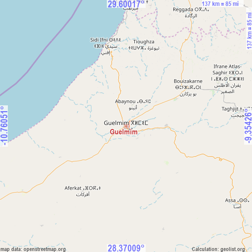
Guelmim GPS coordinates[2]
28° 59' 13.056" North, 10° 3' 26.568" West
| Map corner | latitude | longitude |
|---|---|---|
| Upper-left | 29.60017°, | -10.76051° |
| Center: | 28.98696°, | -10.05738° |
| Lower-right: | 28.37009°, | -9.35426° |
| Map W x H: | 136.8×136.8 km | = 85×85mi |
| max Lat: | 35.84906° ⇑97.7% North |
| Guelmim: | 28.98696° |
| min Lat: | ⇓2.3% South 22.6558° |
| min Long | Guelmim | max Long |
| -15.60719° | -10.05738° | -1.22855° |
| W 2.7%⇐ | ⇒97.3% E |
Elevation
Elevation of Guelmim is 301 m = 988 ft, and this is 315.8 m = 1036 ft below average elevation for this country.
| Max E: |
2637 m = 8652 ft | 64.7% |
| Avg. | 616.8 m = 2024 ft | |
| Guelmim | 301 m = 988 ft | |
Min E: |
1 m = 3 ft | 35.3% |
See also: Guelmim elevation on elevation.city.
Geographical zone
Guelmim is located in North temperate zone (between Tropic of Cancer and the Arctic Circle). Distance of this Northern Tropic circle is 617.1 km =383.4 mi to South.| Distance of | km | miles | from Guelmim |
|---|---|---|---|
| North Pole | 6784 | 4215.4 | to North |
| Arctic Circle | 4178.1 | 2596.2 | to North |
| Tropic Cancer | 617.1 | 383.4 | to South |
| Equator | 3223 | 2002.7 | to South |


Nearby cities:
15 places around Guelmim: (largest is in red/bold)
• Agadir
165.4 km =102.8 mi,  15°
15°
• Aourir
172.3 km =107.1 mi,  13°
13°
• Dakhla
165.6 km =102.9 mi, 17°
• Inezgane
160.3 km =99.6 mi, 18°
• Ouijjane
87.2 km =54.2 mi,  35°
35°
• Oulad Teïma
176.7 km =109.8 mi,  27°
27°
• Reggada
74.5 km =46.3 mi, 27°
• Sidi Ifni
45.1 km =28 mi,  345°
345°
• Tabia
163.1 km =101.3 mi, 44°
• Tafraout
133.2 km =82.8 mi,  51°
51°
• Taghazout
176.2 km =109.5 mi, 10°
• Tan-Tan
118.9 km =73.9 mi,  239°
239°
• Tanalt
122.9 km =76.4 mi, 44°
• Tarsouat
119.8 km =74.4 mi,  56°
56°
• Tiznit
85.1 km =52.9 mi, 21°
Sources, notices
• [Note1] Compared only with cities in Morocco existing in our database
• [Src1] Map data: © OpenStreetMap contributors (CC-BY-SA)
• [Src2] Other city data from geonames.org with taken over terms of usage.
• [Src3] Geographical zone / Annual Mean Temperature by Robert A. Rohde @ Wikipedia
