Giurgiuleşti geodata
Giurgiuleşti (Cahul) is a populated place; located in Moldova in Europe/Chisinau (GMT+3) time zone. With population of 3,074 people, there are 64 cities with bigger population in this country. Compared to other cities in Moldova, 100% of cities are located further ↑North; 78.1% of cities are located further →East and 74% of cities have higher elevation than Giurgiuleşti. Note1


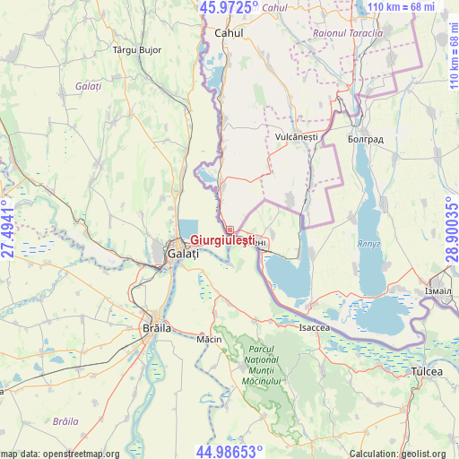
Giurgiuleşti GPS coordinates[2]
45° 28' 54.012" North, 28° 11' 49.992" East
| Map corner | latitude | longitude |
|---|---|---|
| Upper-left | 45.9725°, | 27.4941° |
| Center: | 45.48167°, | 28.19722° |
| Lower-right: | 44.98653°, | 28.90035° |
| Map W x H: | 109.6×109.6 km | = 68.1×68.1mi |
| max Lat: | 48.43285° ⇑100% North |
| Giurgiuleşti: | 45.48167° |
| min Lat: | ⇓0% South 45.48167° |
| min Long | Giurgiuleşti | max Long |
| 27.07787° | 28.19722° | 29.9617° |
| W 21.9%⇐ | ⇒78.1% E |
Elevation
Elevation of Giurgiuleşti is 47 m = 154 ft, and this is 45.8 m = 150 ft below average elevation for this country.
| Max E: |
241 m = 791 ft | 74% |
| Avg. | 92.8 m = 304 ft | |
| Giurgiuleşti | 47 m = 154 ft | |
Min E: |
11 m = 36 ft | 26% |
See also: Moldova elevation on elevation.city.
Geographical zone
Giurgiuleşti is located in North temperate zone (between Tropic of Cancer and the Arctic Circle). Distance of this North polar circle is 2344.1 km =1456.6 mi to North.| Distance of | km | miles | from Giurgiuleşti |
|---|---|---|---|
| North Pole | 4950 | 3075.8 | to North |
| Arctic Circle | 2344.1 | 1456.6 | to North |
| Tropic Cancer | 2451.2 | 1523.1 | to South |
| Equator | 5057.1 | 3142.3 | to South |


Nearby cities:
15 places around Giurgiuleşti: (largest is in red/bold)
• Basarabeasca
111.6 km =69.3 mi,  32°
32°
• Bugeac
104.7 km =65.1 mi,  20°
20°
• Cahul
47 km =29.2 mi,  0°
0°
• Cantemir
88.5 km =55 mi, 0°
• Ceadîr-Lunga
81.1 km =50.4 mi,  37°
37°
• Cimişlia
124.2 km =77.2 mi, 20°
• Comrat
97.1 km =60.3 mi, 21°
• Dancu
141.9 km =88.2 mi, 0°
• Hînceşti
153 km =95.1 mi,  11°
11°
• Iargara
106.4 km =66.1 mi, 9°
• Leova
111.3 km =69.2 mi, 2°
• Taraclia
59.4 km =36.9 mi, 37°
• Tvardița
95 km =59 mi, 38°
• Vişniovca
96.6 km =60 mi, 11°
• Vulcăneşti
27.8 km =17.3 mi, 35°
Sources, notices
• [Note1] Compared only with cities in Moldova existing in our database
• [Src1] Map data: © OpenStreetMap contributors (CC-BY-SA)
• [Src2] Other city data from geonames.org with taken over terms of usage.
• [Src3] Geographical zone / Annual Mean Temperature by Robert A. Rohde @ Wikipedia
