Yanfolila geodata
Yanfolila (Sikasso) is a seat of a second-order administrative division; located in Mali in Africa/Bamako (GMT+0) time zone. In our database, there are 39 cities with bigger population. Compared to other cities in Mali, 96.7% of cities are located further ↑North; 82% of cities are located further →East and 82% of cities have lower elevation than Yanfolila. Note1


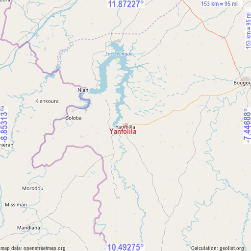
Yanfolila GPS coordinates[2]
11° 10' 59.988" North, 8° 9' 0" West
| Map corner | latitude | longitude |
|---|---|---|
| Upper-left | 11.87227°, | -8.85313° |
| Center: | 11.18333°, | -8.15° |
| Lower-right: | 10.49275°, | -7.44688° |
| Map W x H: | 153.4×153.4 km | = 95.3×95.3mi |
| max Lat: | 22.67443° ⇑96.7% North |
| Yanfolila: | 11.18333° |
| min Lat: | ⇓3.3% South 10.55° |
| min Long | Yanfolila | max Long |
| -11.44448° | -8.15° | 3.14111° |
| W 18%⇐ | ⇒82% E |
Elevation
Elevation of Yanfolila is 363 m = 1191 ft, and this is 55 m = 180 ft above average elevation for this country.
| Max E: |
540 m = 1772 ft | 18% |
| Yanfolila | 363 m 1191 ft | |
| Avg. | 308 m = 1010 ft | |
Min E: |
39 m = 128 ft | 82% |
See also: Mali elevation on elevation.city.
Geographical zone
Yanfolila is located in North Torrid zone (between Equator and Tropic of Cancer). Distance of Equator is 1243.5 km =772.7 mi to South.| Distance of | km | miles | from Yanfolila |
|---|---|---|---|
| North Pole | 8763.6 | 5445.4 | to North |
| Arctic Circle | 6157.7 | 3826.2 | to North |
| Tropic Cancer | 1362.4 | 846.6 | to North |
| Equator | 1243.5 | 772.7 | to South |


Nearby cities:
15 places around Yanfolila: (largest is in red/bold)
• Bamako
163.9 km =101.8 mi,  5°
5°
• Banamba
273.7 km =170.1 mi,  16°
16°
• Barouéli
254.7 km =158.3 mi,  34°
34°
• Bougouni
77.2 km =48 mi,  70°
70°
• Dioila
206.7 km =128.4 mi,  45°
45°
• Figuira-Toma
84.9 km =52.8 mi,  343°
343°
• Kadiolo
269.6 km =167.5 mi,  105°
105°
• Kangaba
88.3 km =54.9 mi, 340°
• Kati
173.7 km =107.9 mi,  2°
2°
• Kita
252.2 km =156.7 mi,  324°
324°
• Kokofata
272.1 km =169.1 mi,  314°
314°
• Kolokani
266 km =165.3 mi, 2°
• Kolondiéba
137.5 km =85.4 mi,  94°
94°
• Koulikoro
197.5 km =122.7 mi, 18°
• Sikasso
271.2 km =168.5 mi, 86°
Sources, notices
• [Note1] Compared only with cities in Mali existing in our database
• [Src1] Map data: © OpenStreetMap contributors (CC-BY-SA)
• [Src2] Other city data from geonames.org with taken over terms of usage.
• [Src3] Geographical zone / Annual Mean Temperature by Robert A. Rohde @ Wikipedia
