Bamako geodata
Bamako is a capital of a political entity; located in Mali in Africa/Bamako (GMT+0) time zone. With population of 1,297,281 people, there are 0 cities with bigger population in this country. Compared to other cities in Mali, 77% of cities are located further ↑North; 77% of cities are located further →East and 70.5% of cities have lower elevation than Bamako. Note1


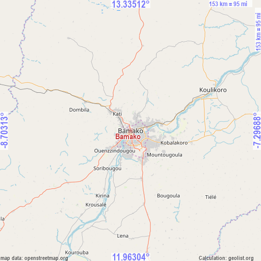
Bamako GPS coordinates[2]
12° 39' 0" North, 8° 0' 0" West
| Map corner | latitude | longitude |
|---|---|---|
| Upper-left | 13.33512°, | -8.70313° |
| Center: | 12.65°, | -8° |
| Lower-right: | 11.96304°, | -7.29688° |
| Map W x H: | 152.6×152.6 km | = 94.8×94.8mi |
| max Lat: | 22.67443° ⇑77% North |
| Bamako: | 12.65° |
| min Lat: | ⇓23% South 10.55° |
| min Long | Bamako | max Long |
| -11.44448° | -8° | 3.14111° |
| W 23%⇐ | ⇒77% E |
Elevation
Elevation of Bamako is 338 m = 1109 ft, and this is 30 m = 98 ft above average elevation for this country.
| Max E: |
540 m = 1772 ft | 29.5% |
| Bamako | 338 m 1109 ft | |
| Avg. | 308 m = 1010 ft | |
Min E: |
39 m = 128 ft | 70.5% |
See also: Bamako elevation on elevation.city.
Geographical zone
Bamako is located in North Torrid zone (between Equator and Tropic of Cancer). Distance of this Northern Tropic circle is 1199.4 km =745.3 mi to North.| Distance of | km | miles | from Bamako |
|---|---|---|---|
| North Pole | 8600.5 | 5344.1 | to North |
| Arctic Circle | 5994.6 | 3724.9 | to North |
| Tropic Cancer | 1199.4 | 745.3 | to North |
| Equator | 1406.5 | 874 | to South |


Nearby cities:
15 places around Bamako: (largest is in red/bold)
• Banamba
116.3 km =72.3 mi,  30°
30°
• Barouéli
135.3 km =84.1 mi,  69°
69°
• Bougouni
148.1 km =92 mi,  157°
157°
• Dioila
132.5 km =82.3 mi,  98°
98°
• Figuira-Toma
90.7 km =56.4 mi,  206°
206°
• Kangaba
91.6 km =56.9 mi, 209°
• Kati
13.1 km =8.1 mi,  323°
323°
• Kita
167 km =103.8 mi,  284°
284°
• Kokofata
213 km =132.4 mi, 276°
• Kolokani
102.7 km =63.8 mi,  357°
357°
• Kolondiéba
211.2 km =131.2 mi,  145°
145°
• Koulikoro
53.3 km =33.1 mi,  63°
63°
• Ségou
211.9 km =131.7 mi, 65°
• Séguéla
213 km =132.4 mi,  40°
40°
• Yanfolila
163.9 km =101.8 mi,  185°
185°
Sources, notices
• [Note1] Compared only with cities in Mali existing in our database
• [Src1] Map data: © OpenStreetMap contributors (CC-BY-SA)
• [Src2] Other city data from geonames.org with taken over terms of usage.
• [Src3] Geographical zone / Annual Mean Temperature by Robert A. Rohde @ Wikipedia
