Banamba geodata
Banamba (Koulikoro) is a seat of a second-order administrative division; located in Mali in Africa/Bamako (GMT+0) time zone. With population of 30,591 people, there are 12 cities with bigger population in this country. Compared to other cities in Mali, 59% of cities are located further ↑North; 72.1% of cities are located further →East and 85.2% of cities have lower elevation than Banamba. Note1


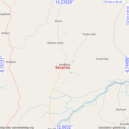
Banamba GPS coordinates[2]
13° 32' 51.828" North, 7° 26' 53.088" West
| Map corner | latitude | longitude |
|---|---|---|
| Upper-left | 14.23029°, | -8.15121° |
| Center: | 13.54773°, | -7.44808° |
| Lower-right: | 12.8632°, | -6.74496° |
| Map W x H: | 152×152 km | = 94.4×94.4mi |
| max Lat: | 22.67443° ⇑59% North |
| Banamba: | 13.54773° |
| min Lat: | ⇓41% South 10.55° |
| min Long | Banamba | max Long |
| -11.44448° | -7.44808° | 3.14111° |
| W 27.9%⇐ | ⇒72.1% E |
Elevation
Elevation of Banamba is 378 m = 1240 ft, and this is 70 m = 230 ft above average elevation for this country.
| Max E: |
540 m = 1772 ft | 14.8% |
| Banamba | 378 m 1240 ft | |
| Avg. | 308 m = 1010 ft | |
Min E: |
39 m = 128 ft | 85.2% |
See also: Mali elevation on elevation.city.
Geographical zone
Banamba is located in North Torrid zone (between Equator and Tropic of Cancer). Distance of this Northern Tropic circle is 1099.6 km =683.3 mi to North.| Distance of | km | miles | from Banamba |
|---|---|---|---|
| North Pole | 8500.7 | 5282.1 | to North |
| Arctic Circle | 5894.8 | 3662.9 | to North |
| Tropic Cancer | 1099.6 | 683.3 | to North |
| Equator | 1506.4 | 936 | to South |


Nearby cities:
15 places around Banamba: (largest is in red/bold)
• Bamako
116.3 km =72.3 mi,  210°
210°
• Barouéli
84.8 km =52.7 mi,  128°
128°
• Bla
194.4 km =120.8 mi,  109°
109°
• Dioila
138.2 km =85.9 mi,  149°
149°
• Figuira-Toma
206.9 km =128.6 mi, 208°
• Kangaba
208 km =129.2 mi, 210°
• Kati
112.1 km =69.7 mi,  217°
217°
• Kolokani
63.4 km =39.4 mi,  272°
272°
• Koulikoro
77.1 km =47.9 mi,  189°
189°
• Markala
150.3 km =93.4 mi,  83°
83°
• Nara
181.1 km =112.5 mi,  5°
5°
• Niono
175.5 km =109.1 mi,  63°
63°
• Sokolo
194.4 km =120.8 mi,  47°
47°
• Ségou
133.9 km =83.2 mi,  95°
95°
• Séguéla
99.9 km =62.1 mi, 51°
Sources, notices
• [Note1] Compared only with cities in Mali existing in our database
• [Src1] Map data: © OpenStreetMap contributors (CC-BY-SA)
• [Src2] Other city data from geonames.org with taken over terms of usage.
• [Src3] Geographical zone / Annual Mean Temperature by Robert A. Rohde @ Wikipedia
