Bougouni geodata
Bougouni (Sikasso) is a populated place; located in Mali in Africa/Bamako (GMT+0) time zone. With population of 35,450 people, there are 10 cities with bigger population in this country. Compared to other cities in Mali, 93.4% of cities are located further ↑North; 73.8% of cities are located further →East and 78.7% of cities have lower elevation than Bougouni. Note1


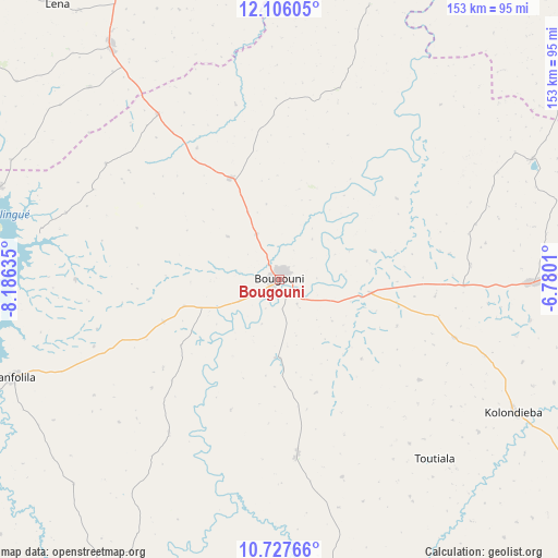
Bougouni GPS coordinates[2]
11° 25' 3.684" North, 7° 28' 59.628" West
| Map corner | latitude | longitude |
|---|---|---|
| Upper-left | 12.10605°, | -8.18635° |
| Center: | 11.41769°, | -7.48323° |
| Lower-right: | 10.72766°, | -6.7801° |
| Map W x H: | 153.3×153.3 km | = 95.3×95.3mi |
| max Lat: | 22.67443° ⇑93.4% North |
| Bougouni: | 11.41769° |
| min Lat: | ⇓6.6% South 10.55° |
| min Long | Bougouni | max Long |
| -11.44448° | -7.48323° | 3.14111° |
| W 26.2%⇐ | ⇒73.8% E |
Elevation
Elevation of Bougouni is 349 m = 1145 ft, and this is 41 m = 135 ft above average elevation for this country.
| Max E: |
540 m = 1772 ft | 21.3% |
| Bougouni | 349 m 1145 ft | |
| Avg. | 308 m = 1010 ft | |
Min E: |
39 m = 128 ft | 78.7% |
See also: Mali elevation on elevation.city.
Geographical zone
Bougouni is located in North Torrid zone (between Equator and Tropic of Cancer). Distance of Equator is 1269.5 km =788.8 mi to South.| Distance of | km | miles | from Bougouni |
|---|---|---|---|
| North Pole | 8737.5 | 5429.2 | to North |
| Arctic Circle | 6131.6 | 3810 | to North |
| Tropic Cancer | 1336.4 | 830.4 | to North |
| Equator | 1269.5 | 788.8 | to South |


Nearby cities:
15 places around Bougouni: (largest is in red/bold)
• Bamako
148.1 km =92 mi,  337°
337°
• Banamba
236.9 km =147.2 mi,  0°
0°
• Barouéli
197.6 km =122.8 mi,  21°
21°
• Dioila
140.3 km =87.2 mi,  32°
32°
• Figuira-Toma
111.1 km =69 mi,  299°
299°
• Kadiolo
210.7 km =130.9 mi,  117°
117°
• Kangaba
116.7 km =72.5 mi, 299°
• Kati
160.8 km =99.9 mi, 336°
• Kolokani
247 km =153.5 mi,  345°
345°
• Kolondiéba
74 km =46 mi, 119°
• Koulikoro
160.9 km =100 mi,  357°
357°
• Koutiala
244.9 km =152.2 mi,  63°
63°
• Ntossoni
223.7 km =139 mi, 56°
• Sikasso
198.3 km =123.2 mi,  93°
93°
• Yanfolila
77.2 km =48 mi,  250°
250°
Sources, notices
• [Note1] Compared only with cities in Mali existing in our database
• [Src1] Map data: © OpenStreetMap contributors (CC-BY-SA)
• [Src2] Other city data from geonames.org with taken over terms of usage.
• [Src3] Geographical zone / Annual Mean Temperature by Robert A. Rohde @ Wikipedia
