Kita geodata
Kita (Kayes) is a seat of a second-order administrative division; located in Mali in Africa/Bamako (GMT+0) time zone. With population of 5,769 people, there are 34 cities with bigger population in this country. Compared to other cities in Mali, 67.2% of cities are located further ↑North; 88.5% of cities are located further →East and 67.2% of cities have lower elevation than Kita. Note1


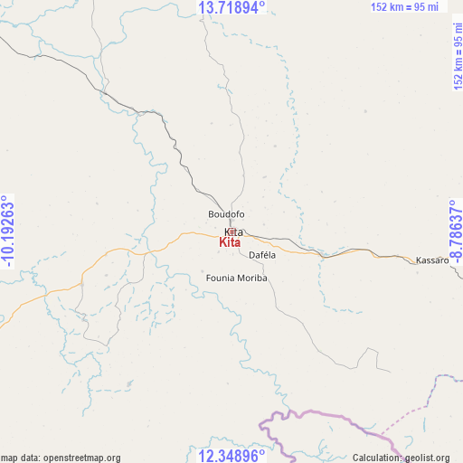
Kita GPS coordinates[2]
13° 2' 5.64" North, 9° 29' 22.2" West
| Map corner | latitude | longitude |
|---|---|---|
| Upper-left | 13.71894°, | -10.19263° |
| Center: | 13.0349°, | -9.4895° |
| Lower-right: | 12.34896°, | -8.78637° |
| Map W x H: | 152.3×152.3 km | = 94.6×94.6mi |
| max Lat: | 22.67443° ⇑67.2% North |
| Kita: | 13.0349° |
| min Lat: | ⇓32.8% South 10.55° |
| min Long | Kita | max Long |
| -11.44448° | -9.4895° | 3.14111° |
| W 11.5%⇐ | ⇒88.5% E |
Elevation
Elevation of Kita is 329 m = 1079 ft, and this is 21 m = 69 ft above average elevation for this country.
| Max E: |
540 m = 1772 ft | 32.8% |
| Kita | 329 m 1079 ft | |
| Avg. | 308 m = 1010 ft | |
Min E: |
39 m = 128 ft | 67.2% |
See also: Mali elevation on elevation.city.
Geographical zone
Kita is located in North Torrid zone (between Equator and Tropic of Cancer). Distance of this Northern Tropic circle is 1156.6 km =718.7 mi to North.| Distance of | km | miles | from Kita |
|---|---|---|---|
| North Pole | 8557.7 | 5317.5 | to North |
| Arctic Circle | 5951.8 | 3698.3 | to North |
| Tropic Cancer | 1156.6 | 718.7 | to North |
| Equator | 1449.3 | 900.6 | to South |


Nearby cities:
15 places around Kita: (largest is in red/bold)
• Bafoulabé
168.7 km =104.8 mi,  300°
300°
• Bamako
167 km =103.8 mi,  104°
104°
• Banamba
228.1 km =141.7 mi,  75°
75°
• Diré
180.7 km =112.3 mi,  242°
242°
• Diéma
170.4 km =105.9 mi,  10°
10°
• Figuira-Toma
174.1 km =108.2 mi,  135°
135°
• Kangaba
169 km =105 mi, 136°
• Kati
156.9 km =97.5 mi, 101°
• Kokofata
52.7 km =32.7 mi,  251°
251°
• Kolokani
168.5 km =104.7 mi,  69°
69°
• Koulikoro
210 km =130.5 mi, 95°
• Nioro
244.3 km =151.8 mi,  357°
357°
• Sagalo
160.8 km =99.9 mi,  234°
234°
• Yanfolila
252.2 km =156.7 mi, 144°
• Yélimané
259.7 km =161.4 mi,  333°
333°
Sources, notices
• [Note1] Compared only with cities in Mali existing in our database
• [Src1] Map data: © OpenStreetMap contributors (CC-BY-SA)
• [Src2] Other city data from geonames.org with taken over terms of usage.
• [Src3] Geographical zone / Annual Mean Temperature by Robert A. Rohde @ Wikipedia
