Koutiala geodata
Koutiala (Sikasso) is a seat of a second-order administrative division; located in Mali in Africa/Bamako (GMT+0) time zone. With population of 99,353 people, there are 3 cities with bigger population in this country. Compared to other cities in Mali, 82% of cities are located further ↑North; 50.8% of cities are located further ←West and 80.3% of cities have lower elevation than Koutiala. Note1


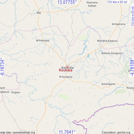
Koutiala GPS coordinates[2]
12° 23' 30.228" North, 5° 27' 51.156" West
| Map corner | latitude | longitude |
|---|---|---|
| Upper-left | 13.07755°, | -6.16734° |
| Center: | 12.39173°, | -5.46421° |
| Lower-right: | 11.7041°, | -4.76109° |
| Map W x H: | 152.7×152.7 km | = 94.9×94.9mi |
| max Lat: | 22.67443° ⇑82% North |
| Koutiala: | 12.39173° |
| min Lat: | ⇓18% South 10.55° |
| min Long | Koutiala | max Long |
| -11.44448° | -5.46421° | 3.14111° |
| W 50.8%⇐ | ⇒49.2% E |
Elevation
Elevation of Koutiala is 351 m = 1152 ft, and this is 43 m = 141 ft above average elevation for this country.
| Max E: |
540 m = 1772 ft | 19.7% |
| Koutiala | 351 m 1152 ft | |
| Avg. | 308 m = 1010 ft | |
Min E: |
39 m = 128 ft | 80.3% |
See also: Koutiala elevation on elevation.city.
Geographical zone
Koutiala is located in North Torrid zone (between Equator and Tropic of Cancer). Distance of this Northern Tropic circle is 1228.1 km =763.1 mi to North.| Distance of | km | miles | from Koutiala |
|---|---|---|---|
| North Pole | 8629.2 | 5361.9 | to North |
| Arctic Circle | 6023.3 | 3742.7 | to North |
| Tropic Cancer | 1228.1 | 763.1 | to North |
| Equator | 1377.8 | 856.1 | to South |


Nearby cities:
15 places around Koutiala: (largest is in red/bold)
• Barouéli
166.7 km =103.6 mi,  297°
297°
• Bla
69.9 km =43.4 mi,  332°
332°
• Dioila
144.4 km =89.7 mi,  273°
273°
• Djénné
195.1 km =121.2 mi,  30°
30°
• Kadiolo
207.4 km =128.9 mi,  189°
189°
• Kinmparana
77.1 km =47.9 mi,  49°
49°
• Ké-Macina
175.2 km =108.9 mi,  3°
3°
• Leleni
23.8 km =14.8 mi,  90°
90°
• Markala
159.6 km =99.2 mi,  335°
335°
• Ntossoni
36.6 km =22.7 mi,  294°
294°
• San
118.6 km =73.7 mi, 31°
• Sikasso
121.4 km =75.4 mi, 190°
• Ségou
141.4 km =87.9 mi,  324°
324°
• Tominian
137.2 km =85.3 mi,  43°
43°
• Yorosso
74.7 km =46.4 mi, 92°
Sources, notices
• [Note1] Compared only with cities in Mali existing in our database
• [Src1] Map data: © OpenStreetMap contributors (CC-BY-SA)
• [Src2] Other city data from geonames.org with taken over terms of usage.
• [Src3] Geographical zone / Annual Mean Temperature by Robert A. Rohde @ Wikipedia
