Markala geodata
Markala (Ségou) is a populated place; located in Mali in Africa/Bamako (GMT+0) time zone. With population of 53,738 people, there are 7 cities with bigger population in this country. Compared to other cities in Mali, 55.7% of cities are located further ↑North; 59% of cities are located further →East and 50.8% of cities have higher elevation than Markala. Note1


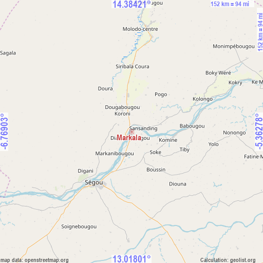
Markala GPS coordinates[2]
13° 42' 7.56" North, 6° 3' 57.24" West
| Map corner | latitude | longitude |
|---|---|---|
| Upper-left | 14.38421°, | -6.76903° |
| Center: | 13.7021°, | -6.0659° |
| Lower-right: | 13.01801°, | -5.36278° |
| Map W x H: | 151.9×151.9 km | = 94.4×94.4mi |
| max Lat: | 22.67443° ⇑55.7% North |
| Markala: | 13.7021° |
| min Lat: | ⇓44.3% South 10.55° |
| min Long | Markala | max Long |
| -11.44448° | -6.0659° | 3.14111° |
| W 41%⇐ | ⇒59% E |
Elevation
Elevation of Markala is 292 m = 958 ft, and this is 16 m = 52 ft below average elevation for this country.
| Max E: |
540 m = 1772 ft | 50.8% |
| Avg. | 308 m = 1010 ft | |
| Markala | 292 m = 958 ft | |
Min E: |
39 m = 128 ft | 49.2% |
See also: Markala elevation on elevation.city.
Geographical zone
Markala is located in North Torrid zone (between Equator and Tropic of Cancer). Distance of this Northern Tropic circle is 1082.4 km =672.6 mi to North.| Distance of | km | miles | from Markala |
|---|---|---|---|
| North Pole | 8483.5 | 5271.4 | to North |
| Arctic Circle | 5877.6 | 3652.2 | to North |
| Tropic Cancer | 1082.4 | 672.6 | to North |
| Equator | 1523.5 | 946.7 | to South |


Nearby cities:
15 places around Markala: (largest is in red/bold)
• Banamba
150.3 km =93.4 mi,  263°
263°
• Barouéli
108.1 km =67.2 mi,  229°
229°
• Bla
89.9 km =55.9 mi,  158°
158°
• Dioila
156.7 km =97.4 mi,  210°
210°
• Djénné
164.9 km =102.5 mi,  82°
82°
• Kinmparana
156.2 km =97.1 mi,  127°
127°
• Koutiala
159.6 km =99.2 mi, 155°
• Ké-Macina
81.8 km =50.8 mi,  69°
69°
• Niono
61.7 km =38.3 mi,  7°
7°
• Ntossoni
134.2 km =83.4 mi,  166°
166°
• San
134.1 km =83.3 mi,  109°
109°
• Sokolo
114.8 km =71.3 mi,  356°
356°
• Ségou
34.1 km =21.2 mi, 208°
• Séguéla
84.9 km =52.8 mi,  302°
302°
• Ténenkou
149.7 km =93 mi,  55°
55°
Sources, notices
• [Note1] Compared only with cities in Mali existing in our database
• [Src1] Map data: © OpenStreetMap contributors (CC-BY-SA)
• [Src2] Other city data from geonames.org with taken over terms of usage.
• [Src3] Geographical zone / Annual Mean Temperature by Robert A. Rohde @ Wikipedia
