Leleni geodata
Leleni (Sikasso) is a seat of a third-order administrative division; located in Mali in Africa/Bamako (GMT+0) time zone. In our database, there are 39 cities with bigger population. Compared to other cities in Mali, 83.6% of cities are located further ↑North; 54.1% of cities are located further ←West and 73.8% of cities have lower elevation than Leleni. Note1


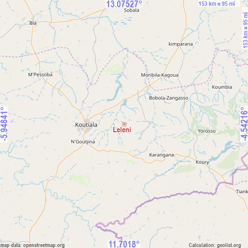
Leleni GPS coordinates[2]
12° 23' 21.984" North, 5° 14' 43.008" West
| Map corner | latitude | longitude |
|---|---|---|
| Upper-left | 13.07527°, | -5.94841° |
| Center: | 12.38944°, | -5.24528° |
| Lower-right: | 11.7018°, | -4.54216° |
| Map W x H: | 152.7×152.7 km | = 94.9×94.9mi |
| max Lat: | 22.67443° ⇑83.6% North |
| Leleni: | 12.38944° |
| min Lat: | ⇓16.4% South 10.55° |
| min Long | Leleni | max Long |
| -11.44448° | -5.24528° | 3.14111° |
| W 54.1%⇐ | ⇒45.9% E |
Elevation
Elevation of Leleni is 341 m = 1119 ft, and this is 33 m = 108 ft above average elevation for this country.
| Max E: |
540 m = 1772 ft | 26.2% |
| Leleni | 341 m 1119 ft | |
| Avg. | 308 m = 1010 ft | |
Min E: |
39 m = 128 ft | 73.8% |
See also: Mali elevation on elevation.city.
Geographical zone
Leleni is located in North Torrid zone (between Equator and Tropic of Cancer). Distance of this Northern Tropic circle is 1228.3 km =763.2 mi to North.| Distance of | km | miles | from Leleni |
|---|---|---|---|
| North Pole | 8629.5 | 5362.1 | to North |
| Arctic Circle | 6023.6 | 3742.9 | to North |
| Tropic Cancer | 1228.3 | 763.2 | to North |
| Equator | 1377.6 | 856 | to South |


Nearby cities:
15 places around Leleni: (largest is in red/bold)
• Barouéli
188.2 km =116.9 mi,  293°
293°
• Bla
83.7 km =52 mi,  318°
318°
• Dioila
168.2 km =104.5 mi,  273°
273°
• Djénné
184.5 km =114.6 mi,  23°
23°
• Kadiolo
212.3 km =131.9 mi,  195°
195°
• Kinmparana
61.2 km =38 mi,  34°
34°
• Koutiala
23.8 km =14.8 mi, 270°
• Ké-Macina
175.5 km =109.1 mi,  356°
356°
• Markala
170.9 km =106.2 mi,  328°
328°
• Ntossoni
59.1 km =36.7 mi, 285°
• San
108.5 km =67.4 mi, 20°
• Sikasso
127.7 km =79.3 mi, 201°
• Ségou
156.5 km =97.2 mi, 317°
• Tominian
122.3 km =76 mi,  35°
35°
• Yorosso
51 km =31.7 mi,  93°
93°
Sources, notices
• [Note1] Compared only with cities in Mali existing in our database
• [Src1] Map data: © OpenStreetMap contributors (CC-BY-SA)
• [Src2] Other city data from geonames.org with taken over terms of usage.
• [Src3] Geographical zone / Annual Mean Temperature by Robert A. Rohde @ Wikipedia
