Ségou geodata
Ségou is a seat of a first-order administrative division; located in Mali in Africa/Bamako (GMT+0) time zone. With population of 92,552 people, there are 4 cities with bigger population in this country. Compared to other cities in Mali, 60.7% of cities are located further ↑North; 62.3% of cities are located further →East and 57.4% of cities have higher elevation than Ségou. Note1


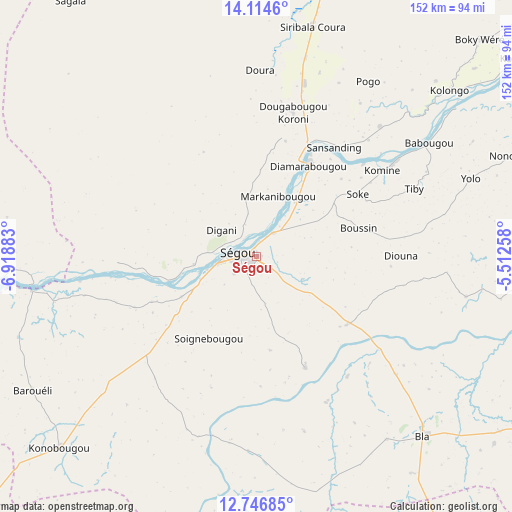
Ségou GPS coordinates[2]
13° 25' 54.12" North, 6° 12' 56.52" West
| Map corner | latitude | longitude |
|---|---|---|
| Upper-left | 14.1146°, | -6.91883° |
| Center: | 13.4317°, | -6.2157° |
| Lower-right: | 12.74685°, | -5.51258° |
| Map W x H: | 152.1×152.1 km | = 94.5×94.5mi |
| max Lat: | 22.67443° ⇑60.7% North |
| Ségou: | 13.4317° |
| min Lat: | ⇓39.3% South 10.55° |
| min Long | Ségou | max Long |
| -11.44448° | -6.2157° | 3.14111° |
| W 37.7%⇐ | ⇒62.3% E |
Elevation
Elevation of Ségou is 288 m = 945 ft, and this is 20 m = 66 ft below average elevation for this country.
| Max E: |
540 m = 1772 ft | 57.4% |
| Avg. | 308 m = 1010 ft | |
| Ségou | 288 m = 945 ft | |
Min E: |
39 m = 128 ft | 42.6% |
See also: Ségou elevation on elevation.city.
Geographical zone
Ségou is located in North Torrid zone (between Equator and Tropic of Cancer). Distance of this Northern Tropic circle is 1112.5 km =691.3 mi to North.| Distance of | km | miles | from Ségou |
|---|---|---|---|
| North Pole | 8513.6 | 5290.1 | to North |
| Arctic Circle | 5907.7 | 3670.9 | to North |
| Tropic Cancer | 1112.5 | 691.3 | to North |
| Equator | 1493.5 | 928 | to South |


Nearby cities:
15 places around Ségou: (largest is in red/bold)
• Banamba
133.9 km =83.2 mi,  275°
275°
• Barouéli
77.4 km =48.1 mi,  239°
239°
• Bla
72.8 km =45.2 mi,  137°
137°
• Dioila
122.6 km =76.2 mi,  210°
210°
• Kinmparana
154.4 km =95.9 mi,  115°
115°
• Koulikoro
158.7 km =98.6 mi,  246°
246°
• Koutiala
141.4 km =87.9 mi, 144°
• Ké-Macina
110 km =68.4 mi,  57°
57°
• Leleni
156.5 km =97.2 mi, 137°
• Markala
34.1 km =21.2 mi,  28°
28°
• Niono
94.4 km =58.7 mi,  14°
14°
• Ntossoni
111.2 km =69.1 mi,  154°
154°
• San
143.5 km =89.2 mi,  95°
95°
• Sokolo
145 km =90.1 mi,  3°
3°
• Séguéla
93.8 km =58.3 mi,  323°
323°
Sources, notices
• [Note1] Compared only with cities in Mali existing in our database
• [Src1] Map data: © OpenStreetMap contributors (CC-BY-SA)
• [Src2] Other city data from geonames.org with taken over terms of usage.
• [Src3] Geographical zone / Annual Mean Temperature by Robert A. Rohde @ Wikipedia
