San geodata
San (Ségou) is a seat of a second-order administrative division; located in Mali in Africa/Bamako (GMT+0) time zone. With population of 24,811 people, there are 14 cities with bigger population in this country. Compared to other cities in Mali, 62.3% of cities are located further ↑North; 59% of cities are located further ←West and 60.7% of cities have higher elevation than San. Note1


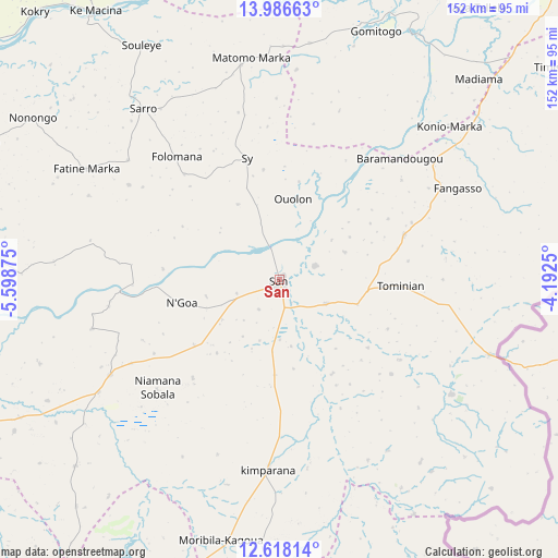
San GPS coordinates[2]
13° 18' 12.06" North, 4° 53' 44.232" West
| Map corner | latitude | longitude |
|---|---|---|
| Upper-left | 13.98663°, | -5.59875° |
| Center: | 13.30335°, | -4.89562° |
| Lower-right: | 12.61814°, | -4.1925° |
| Map W x H: | 152.2×152.2 km | = 94.6×94.6mi |
| max Lat: | 22.67443° ⇑62.3% North |
| San: | 13.30335° |
| min Lat: | ⇓37.7% South 10.55° |
| min Long | San | max Long |
| -11.44448° | -4.89562° | 3.14111° |
| W 59%⇐ | ⇒41% E |
Elevation
Elevation of San is 285 m = 935 ft, and this is 23 m = 75 ft below average elevation for this country.
| Max E: |
540 m = 1772 ft | 60.7% |
| Avg. | 308 m = 1010 ft | |
| San | 285 m = 935 ft | |
Min E: |
39 m = 128 ft | 39.3% |
See also: Mali elevation on elevation.city.
Geographical zone
San is located in North Torrid zone (between Equator and Tropic of Cancer). Distance of this Northern Tropic circle is 1126.7 km =700.1 mi to North.| Distance of | km | miles | from San |
|---|---|---|---|
| North Pole | 8527.9 | 5299 | to North |
| Arctic Circle | 5922 | 3679.8 | to North |
| Tropic Cancer | 1126.7 | 700.1 | to North |
| Equator | 1479.2 | 919.1 | to South |


Nearby cities:
15 places around San: (largest is in red/bold)
• Bankass
172.1 km =106.9 mi,  59°
59°
• Bla
101.5 km =63.1 mi,  247°
247°
• Djénné
76.5 km =47.5 mi,  28°
28°
• Kinmparana
51.4 km =31.9 mi,  183°
183°
• Koutiala
118.6 km =73.7 mi,  211°
211°
• Ké-Macina
88.8 km =55.2 mi,  325°
325°
• Leleni
108.5 km =67.4 mi,  200°
200°
• Markala
134.1 km =83.3 mi,  289°
289°
• Mopti
152.2 km =94.6 mi, 30°
• Niono
158.7 km =98.6 mi,  311°
311°
• Ntossoni
127.9 km =79.5 mi,  227°
227°
• Ségou
143.5 km =89.2 mi,  275°
275°
• Tominian
32.8 km =20.4 mi,  93°
93°
• Ténenkou
128.3 km =79.7 mi,  358°
358°
• Yorosso
105.9 km =65.8 mi,  173°
173°
Sources, notices
• [Note1] Compared only with cities in Mali existing in our database
• [Src1] Map data: © OpenStreetMap contributors (CC-BY-SA)
• [Src2] Other city data from geonames.org with taken over terms of usage.
• [Src3] Geographical zone / Annual Mean Temperature by Robert A. Rohde @ Wikipedia
