Djénné geodata
Djénné (Mopti) is a populated place; located in Mali in Africa/Bamako (GMT+0) time zone. With population of 22,382 people, there are 16 cities with bigger population in this country. Compared to other cities in Mali, 52.5% of cities are located further ↑North; 63.9% of cities are located further ←West and 63.9% of cities have higher elevation than Djénné. Note1


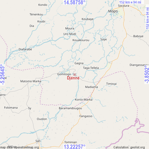
Djénné GPS coordinates[2]
13° 54' 21.888" North, 4° 33' 11.952" West
| Map corner | latitude | longitude |
|---|---|---|
| Upper-left | 14.58758°, | -5.25645° |
| Center: | 13.90608°, | -4.55332° |
| Lower-right: | 13.22257°, | -3.8502° |
| Map W x H: | 151.8×151.8 km | = 94.3×94.3mi |
| max Lat: | 22.67443° ⇑52.5% North |
| Djénné: | 13.90608° |
| min Lat: | ⇓47.5% South 10.55° |
| min Long | Djénné | max Long |
| -11.44448° | -4.55332° | 3.14111° |
| W 63.9%⇐ | ⇒36.1% E |
Elevation
Elevation of Djénné is 278 m = 912 ft, and this is 30 m = 98 ft below average elevation for this country.
| Max E: |
540 m = 1772 ft | 63.9% |
| Avg. | 308 m = 1010 ft | |
| Djénné | 278 m = 912 ft | |
Min E: |
39 m = 128 ft | 36.1% |
See also: Mali elevation on elevation.city.
Geographical zone
Djénné is located in North Torrid zone (between Equator and Tropic of Cancer). Distance of this Northern Tropic circle is 1059.7 km =658.5 mi to North.| Distance of | km | miles | from Djénné |
|---|---|---|---|
| North Pole | 8460.9 | 5257.4 | to North |
| Arctic Circle | 5855 | 3638.1 | to North |
| Tropic Cancer | 1059.7 | 658.5 | to North |
| Equator | 1546.2 | 960.8 | to South |


Nearby cities:
15 places around Djénné: (largest is in red/bold)
• Bandiagara
113 km =70.2 mi,  64°
64°
• Bankass
113.5 km =70.5 mi,  80°
80°
• Bla
168.3 km =104.6 mi,  230°
230°
• Kinmparana
124.9 km =77.6 mi,  198°
198°
• Koro
160.4 km =99.7 mi, 83°
• Ké-Macina
87.1 km =54.1 mi,  274°
274°
• Leleni
184.5 km =114.6 mi, 203°
• Markala
164.9 km =102.5 mi,  262°
262°
• Mopti
75.7 km =47 mi,  31°
31°
• Niono
160 km =99.4 mi,  283°
283°
• San
76.5 km =47.5 mi,  208°
208°
• Tominian
68.9 km =42.8 mi,  183°
183°
• Ténenkou
72.7 km =45.2 mi,  327°
327°
• Yorosso
173.8 km =108 mi,  188°
188°
• Youwarou
165.6 km =102.9 mi,  10°
10°
Sources, notices
• [Note1] Compared only with cities in Mali existing in our database
• [Src1] Map data: © OpenStreetMap contributors (CC-BY-SA)
• [Src2] Other city data from geonames.org with taken over terms of usage.
• [Src3] Geographical zone / Annual Mean Temperature by Robert A. Rohde @ Wikipedia
