Ké-Macina geodata
Ké-Macina (Ségou) is a seat of a second-order administrative division; located in Mali in Africa/Bamako (GMT+0) time zone. With population of 9,848 people, there are 24 cities with bigger population in this country. Compared to other cities in Mali, 50.8% of cities are located further ↑North; 52.5% of cities are located further ←West and 62.3% of cities have higher elevation than Ké-Macina. Note1


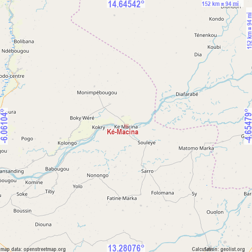
Ké-Macina GPS coordinates[2]
13° 57' 50.76" North, 5° 21' 28.476" West
| Map corner | latitude | longitude |
|---|---|---|
| Upper-left | 14.64542°, | -6.06104° |
| Center: | 13.9641°, | -5.35791° |
| Lower-right: | 13.28076°, | -4.65479° |
| Map W x H: | 151.7×151.7 km | = 94.3×94.3mi |
| max Lat: | 22.67443° ⇑50.8% North |
| Ké-Macina: | 13.9641° |
| min Lat: | ⇓49.2% South 10.55° |
| min Long | Ké-Macina | max Long |
| -11.44448° | -5.35791° | 3.14111° |
| W 52.5%⇐ | ⇒47.5% E |
Elevation
Elevation of Ké-Macina is 283 m = 928 ft, and this is 25 m = 82 ft below average elevation for this country.
| Max E: |
540 m = 1772 ft | 62.3% |
| Avg. | 308 m = 1010 ft | |
| Ké-Macina | 283 m = 928 ft | |
Min E: |
39 m = 128 ft | 37.7% |
See also: Mali elevation on elevation.city.
Geographical zone
Ké-Macina is located in North Torrid zone (between Equator and Tropic of Cancer). Distance of this Northern Tropic circle is 1053.3 km =654.5 mi to North.| Distance of | km | miles | from Ké-Macina |
|---|---|---|---|
| North Pole | 8454.4 | 5253.3 | to North |
| Arctic Circle | 5848.5 | 3634.1 | to North |
| Tropic Cancer | 1053.3 | 654.5 | to North |
| Equator | 1552.7 | 964.8 | to South |


Nearby cities:
15 places around Ké-Macina: (largest is in red/bold)
• Bla
120.9 km =75.1 mi,  201°
201°
• Djénné
87.1 km =54.1 mi,  94°
94°
• Kinmparana
133.3 km =82.8 mi,  159°
159°
• Koutiala
175.2 km =108.9 mi,  183°
183°
• Leleni
175.5 km =109.1 mi, 176°
• Markala
81.8 km =50.8 mi,  249°
249°
• Mopti
139.2 km =86.5 mi,  65°
65°
• Niono
75.6 km =47 mi,  295°
295°
• Ntossoni
165.5 km =102.8 mi, 195°
• San
88.8 km =55.2 mi,  145°
145°
• Sokolo
118.7 km =73.8 mi,  316°
316°
• Ségou
110 km =68.4 mi,  237°
237°
• Séguéla
148.8 km =92.5 mi,  276°
276°
• Tominian
111.8 km =69.5 mi,  132°
132°
• Ténenkou
72.6 km =45.1 mi,  40°
40°
Sources, notices
• [Note1] Compared only with cities in Mali existing in our database
• [Src1] Map data: © OpenStreetMap contributors (CC-BY-SA)
• [Src2] Other city data from geonames.org with taken over terms of usage.
• [Src3] Geographical zone / Annual Mean Temperature by Robert A. Rohde @ Wikipedia
