Ténenkou geodata
Ténenkou (Mopti) is a seat of a second-order administrative division; located in Mali in Africa/Bamako (GMT+0) time zone. With population of 7,471 people, there are 30 cities with bigger population in this country. Compared to other cities in Mali, 60.7% of cities are located further ↓South; 57.4% of cities are located further ←West and 70.5% of cities have higher elevation than Ténenkou. Note1


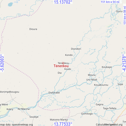
Ténenkou GPS coordinates[2]
14° 27' 25.992" North, 4° 55' 0.84" West
| Map corner | latitude | longitude |
|---|---|---|
| Upper-left | 15.13702°, | -5.62003° |
| Center: | 14.45722°, | -4.9169° |
| Lower-right: | 13.77533°, | -4.21378° |
| Map W x H: | 151.4×151.4 km | = 94.1×94.1mi |
| max Lat: | 22.67443° ⇑39.3% North |
| Ténenkou: | 14.45722° |
| min Lat: | ⇓60.7% South 10.55° |
| min Long | Ténenkou | max Long |
| -11.44448° | -4.9169° | 3.14111° |
| W 57.4%⇐ | ⇒42.6% E |
Elevation
Elevation of Ténenkou is 273 m = 896 ft, and this is 35 m = 115 ft below average elevation for this country.
| Max E: |
540 m = 1772 ft | 70.5% |
| Avg. | 308 m = 1010 ft | |
| Ténenkou | 273 m = 896 ft | |
Min E: |
39 m = 128 ft | 29.5% |
See also: Mali elevation on elevation.city.
Geographical zone
Ténenkou is located in North Torrid zone (between Equator and Tropic of Cancer). Distance of this Northern Tropic circle is 998.4 km =620.4 mi to North.| Distance of | km | miles | from Ténenkou |
|---|---|---|---|
| North Pole | 8399.6 | 5219.3 | to North |
| Arctic Circle | 5793.7 | 3600 | to North |
| Tropic Cancer | 998.4 | 620.4 | to North |
| Equator | 1607.5 | 998.9 | to South |


Nearby cities:
15 places around Ténenkou: (largest is in red/bold)
• Bandiagara
141.2 km =87.7 mi,  94°
94°
• Bankass
156.8 km =97.4 mi,  105°
105°
• Bla
190.7 km =118.5 mi,  208°
208°
• Djénné
72.7 km =45.2 mi,  147°
147°
• Kinmparana
179.6 km =111.6 mi,  180°
180°
• Ké-Macina
72.6 km =45.1 mi,  220°
220°
• Markala
149.7 km =93 mi,  235°
235°
• Mopti
79.1 km =49.2 mi, 87°
• Niafunké
191.8 km =119.2 mi,  31°
31°
• Niono
118.1 km =73.4 mi,  258°
258°
• San
128.3 km =79.7 mi, 178°
• Sokolo
133.2 km =82.8 mi,  283°
283°
• Ségou
180.7 km =112.3 mi,  230°
230°
• Tominian
134.7 km =83.7 mi,  164°
164°
• Youwarou
123.3 km =76.6 mi, 34°
Sources, notices
• [Note1] Compared only with cities in Mali existing in our database
• [Src1] Map data: © OpenStreetMap contributors (CC-BY-SA)
• [Src2] Other city data from geonames.org with taken over terms of usage.
• [Src3] Geographical zone / Annual Mean Temperature by Robert A. Rohde @ Wikipedia
