Youwarou geodata
Youwarou (Mopti) is a seat of a second-order administrative division; located in Mali in Africa/Bamako (GMT+0) time zone. In our database, there are 39 cities with bigger population. Compared to other cities in Mali, 73.8% of cities are located further ↓South; 65.6% of cities are located further ←West and 78.7% of cities have higher elevation than Youwarou. Note1


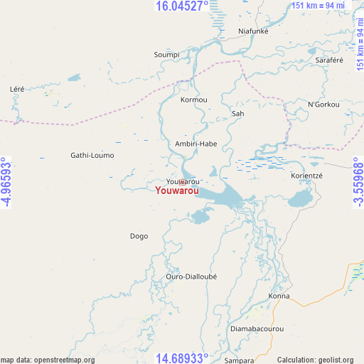
Youwarou GPS coordinates[2]
15° 22' 6.24" North, 4° 15' 46.08" West
| Map corner | latitude | longitude |
|---|---|---|
| Upper-left | 16.04527°, | -4.96593° |
| Center: | 15.3684°, | -4.2628° |
| Lower-right: | 14.68933°, | -3.55968° |
| Map W x H: | 150.8×150.8 km | = 93.7×93.7mi |
| max Lat: | 22.67443° ⇑26.2% North |
| Youwarou: | 15.3684° |
| min Lat: | ⇓73.8% South 10.55° |
| min Long | Youwarou | max Long |
| -11.44448° | -4.2628° | 3.14111° |
| W 65.6%⇐ | ⇒34.4% E |
Elevation
Elevation of Youwarou is 268 m = 879 ft, and this is 40 m = 131 ft below average elevation for this country.
| Max E: |
540 m = 1772 ft | 78.7% |
| Avg. | 308 m = 1010 ft | |
| Youwarou | 268 m = 879 ft | |
Min E: |
39 m = 128 ft | 21.3% |
See also: Mali elevation on elevation.city.
Geographical zone
Youwarou is located in North Torrid zone (between Equator and Tropic of Cancer). Distance of this Northern Tropic circle is 897.1 km =557.4 mi to North.| Distance of | km | miles | from Youwarou |
|---|---|---|---|
| North Pole | 8298.3 | 5156.3 | to North |
| Arctic Circle | 5692.4 | 3537.1 | to North |
| Tropic Cancer | 897.1 | 557.4 | to North |
| Equator | 1708.8 | 1061.8 | to South |


Nearby cities:
15 places around Youwarou: (largest is in red/bold)
• Bandiagara
133.2 km =82.8 mi,  148°
148°
• Bankass
164.5 km =102.2 mi, 150°
• Diré
135.1 km =83.9 mi,  43°
43°
• Djénné
165.6 km =102.9 mi,  190°
190°
• Douentza
146.7 km =91.2 mi,  106°
106°
• Goundam
132.4 km =82.3 mi,  28°
28°
• Koro
193.2 km =120 mi,  138°
138°
• Ké-Macina
195.6 km =121.5 mi,  217°
217°
• Mopti
98.7 km =61.3 mi,  175°
175°
• Niafunké
69.1 km =42.9 mi,  24°
24°
• Niono
223.6 km =138.9 mi,  236°
236°
• Sokolo
211.8 km =131.6 mi,  250°
250°
• Timbuktu
205.9 km =127.9 mi, 40°
• Tominian
234.1 km =145.5 mi, 188°
• Ténenkou
123.3 km =76.6 mi,  214°
214°
Sources, notices
• [Note1] Compared only with cities in Mali existing in our database
• [Src1] Map data: © OpenStreetMap contributors (CC-BY-SA)
• [Src2] Other city data from geonames.org with taken over terms of usage.
• [Src3] Geographical zone / Annual Mean Temperature by Robert A. Rohde @ Wikipedia
