Mopti geodata
Mopti is a seat of a first-order administrative division; located in Mali in Africa/Bamako (GMT+0) time zone. With population of 108,456 people, there are 2 cities with bigger population in this country. Compared to other cities in Mali, 62.3% of cities are located further ↓South; 67.2% of cities are located further ←West and 78.7% of cities have higher elevation than Mopti. Note1


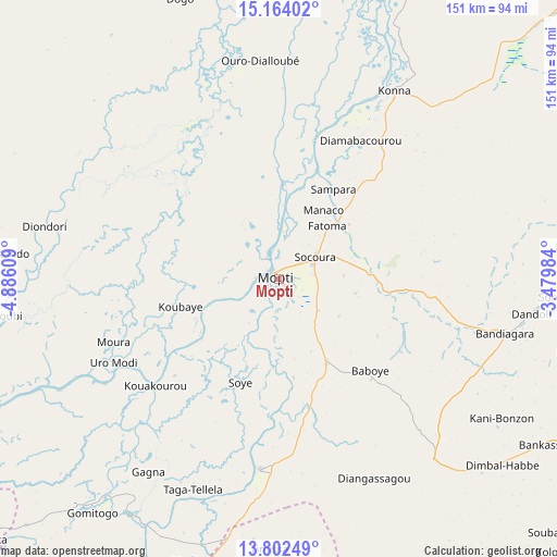
Mopti GPS coordinates[2]
14° 29' 3.48" North, 4° 10' 58.656" West
| Map corner | latitude | longitude |
|---|---|---|
| Upper-left | 15.16402°, | -4.88609° |
| Center: | 14.4843°, | -4.18296° |
| Lower-right: | 13.80249°, | -3.47984° |
| Map W x H: | 151.4×151.4 km | = 94.1×94.1mi |
| max Lat: | 22.67443° ⇑37.7% North |
| Mopti: | 14.4843° |
| min Lat: | ⇓62.3% South 10.55° |
| min Long | Mopti | max Long |
| -11.44448° | -4.18296° | 3.14111° |
| W 67.2%⇐ | ⇒32.8% E |
Elevation
Elevation of Mopti is 268 m = 879 ft, and this is 40 m = 131 ft below average elevation for this country.
| Max E: |
540 m = 1772 ft | 78.7% |
| Avg. | 308 m = 1010 ft | |
| Mopti | 268 m = 879 ft | |
Min E: |
39 m = 128 ft | 21.3% |
See also: Mopti elevation on elevation.city.
Geographical zone
Mopti is located in North Torrid zone (between Equator and Tropic of Cancer). Distance of this Northern Tropic circle is 995.4 km =618.5 mi to North.| Distance of | km | miles | from Mopti |
|---|---|---|---|
| North Pole | 8396.6 | 5217.4 | to North |
| Arctic Circle | 5790.7 | 3598.2 | to North |
| Tropic Cancer | 995.4 | 618.5 | to North |
| Equator | 1610.5 | 1000.7 | to South |


Nearby cities:
15 places around Mopti: (largest is in red/bold)
• Bandiagara
63.4 km =39.4 mi,  103°
103°
• Bankass
84.9 km =52.8 mi,  122°
122°
• Diré
214.2 km =133.1 mi,  23°
23°
• Djénné
75.7 km =47 mi,  211°
211°
• Douentza
144.5 km =89.8 mi,  66°
66°
• Kinmparana
199.4 km =123.9 mi,  203°
203°
• Koro
128.2 km =79.7 mi,  111°
111°
• Ké-Macina
139.2 km =86.5 mi,  245°
245°
• Niafunké
162.3 km =100.8 mi,  7°
7°
• Niono
196.7 km =122.2 mi,  262°
262°
• San
152.2 km =94.6 mi, 210°
• Sokolo
210.4 km =130.7 mi,  277°
277°
• Tominian
140.3 km =87.2 mi, 198°
• Ténenkou
79.1 km =49.2 mi,  267°
267°
• Youwarou
98.7 km =61.3 mi,  355°
355°
Sources, notices
• [Note1] Compared only with cities in Mali existing in our database
• [Src1] Map data: © OpenStreetMap contributors (CC-BY-SA)
• [Src2] Other city data from geonames.org with taken over terms of usage.
• [Src3] Geographical zone / Annual Mean Temperature by Robert A. Rohde @ Wikipedia
