Bandiagara geodata
Bandiagara (Mopti) is a populated place; located in Mali in Africa/Bamako (GMT+0) time zone. With population of 6,853 people, there are 32 cities with bigger population in this country. Compared to other cities in Mali, 57.4% of cities are located further ↓South; 73.8% of cities are located further ←West and 86.9% of cities have lower elevation than Bandiagara. Note1


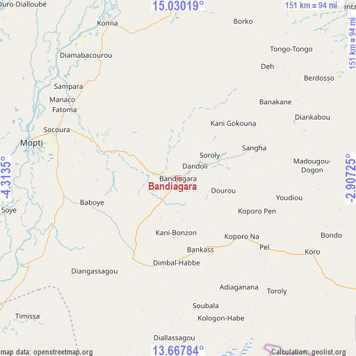
Bandiagara GPS coordinates[2]
14° 21' 0.18" North, 3° 36' 37.368" West
| Map corner | latitude | longitude |
|---|---|---|
| Upper-left | 15.03019°, | -4.3135° |
| Center: | 14.35005°, | -3.61038° |
| Lower-right: | 13.66784°, | -2.90725° |
| Map W x H: | 151.5×151.5 km | = 94.1×94.1mi |
| max Lat: | 22.67443° ⇑42.6% North |
| Bandiagara: | 14.35005° |
| min Lat: | ⇓57.4% South 10.55° |
| min Long | Bandiagara | max Long |
| -11.44448° | -3.61038° | 3.14111° |
| W 73.8%⇐ | ⇒26.2% E |
Elevation
Elevation of Bandiagara is 388 m = 1273 ft, and this is 80 m = 262 ft above average elevation for this country.
| Max E: |
540 m = 1772 ft | 13.1% |
| Bandiagara | 388 m 1273 ft | |
| Avg. | 308 m = 1010 ft | |
Min E: |
39 m = 128 ft | 86.9% |
See also: Mali elevation on elevation.city.
Geographical zone
Bandiagara is located in North Torrid zone (between Equator and Tropic of Cancer). Distance of this Northern Tropic circle is 1010.3 km =627.8 mi to North.| Distance of | km | miles | from Bandiagara |
|---|---|---|---|
| North Pole | 8411.5 | 5226.7 | to North |
| Arctic Circle | 5805.6 | 3607.4 | to North |
| Tropic Cancer | 1010.3 | 627.8 | to North |
| Equator | 1595.6 | 991.5 | to South |


Nearby cities:
15 places around Bandiagara: (largest is in red/bold)
• Bankass
32 km =19.9 mi,  161°
161°
• Diré
213.2 km =132.5 mi,  6°
6°
• Djénné
113 km =70.2 mi,  244°
244°
• Douentza
101.5 km =63.1 mi,  44°
44°
• Goundam
229.6 km =142.7 mi,  358°
358°
• Kinmparana
219.7 km =136.5 mi,  220°
220°
• Koro
65.9 km =40.9 mi,  118°
118°
• Ké-Macina
193.2 km =120 mi,  257°
257°
• Mopti
63.4 km =39.4 mi,  283°
283°
• Niafunké
180.6 km =112.2 mi,  346°
346°
• San
181.1 km =112.5 mi,  230°
230°
• Tominian
158.8 km =98.7 mi, 221°
• Ténenkou
141.2 km =87.7 mi,  274°
274°
• Yorosso
254.9 km =158.4 mi,  209°
209°
• Youwarou
133.2 km =82.8 mi,  328°
328°
Sources, notices
• [Note1] Compared only with cities in Mali existing in our database
• [Src1] Map data: © OpenStreetMap contributors (CC-BY-SA)
• [Src2] Other city data from geonames.org with taken over terms of usage.
• [Src3] Geographical zone / Annual Mean Temperature by Robert A. Rohde @ Wikipedia
