Rashaant geodata
Rashaant (Hövsgöl) is a seat of a second-order administrative division; located in Mongolia in Asia/Ulaanbaatar (GMT+8) time zone. In our database, there are 33 cities with bigger population. Compared to other cities in Mongolia, 79.4% of cities are located further ↓South; 57.7% of cities are located further →East and 50.9% of cities have lower elevation than Rashaant. Note1


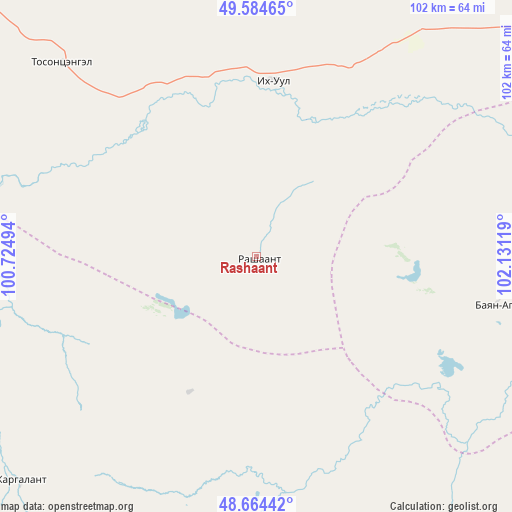
Rashaant GPS coordinates[2]
49° 7' 36.012" North, 101° 25' 41.016" East
| Map corner | latitude | longitude |
|---|---|---|
| Upper-left | 49.58465°, | 100.72494° |
| Center: | 49.12667°, | 101.42806° |
| Lower-right: | 48.66442°, | 102.13119° |
| Map W x H: | 102.3×102.3 km | = 63.6×63.6mi |
| max Lat: | 51.50725° ⇑20.6% North |
| Rashaant: | 49.12667° |
| min Lat: | ⇓79.4% South 42.84199° |
| min Long | Rashaant | max Long |
| 89.14358° | 101.42806° | 118.51014° |
| W 42.3%⇐ | ⇒57.7% E |
Elevation
Elevation of Rashaant is 1395 m = 4577 ft, and this is 21.5 m = 71 ft below average elevation for this country.
| Max E: |
2800 m = 9186 ft | 49.1% |
| Avg. | 1416.5 m = 4647 ft | |
| Rashaant | 1395 m = 4577 ft | |
Min E: |
619 m = 2031 ft | 50.9% |
See also: Mongolia elevation on elevation.city.
Geographical zone
Rashaant is located in North temperate zone (between Tropic of Cancer and the Arctic Circle). Distance of this North polar circle is 1938.8 km =1204.7 mi to North.| Distance of | km | miles | from Rashaant |
|---|---|---|---|
| North Pole | 4544.7 | 2823.9 | to North |
| Arctic Circle | 1938.8 | 1204.7 | to North |
| Tropic Cancer | 2856.5 | 1774.9 | to South |
| Equator | 5462.4 | 3394.2 | to South |


Nearby cities:
15 places around Rashaant: (largest is in red/bold)
• Badrah
68.1 km =42.3 mi,  36°
36°
• Bayantsagaan
65.7 km =40.8 mi,  228°
228°
• Bulag
99.9 km =62.1 mi,  324°
324°
• Eg-Uur
109.8 km =68.2 mi,  5°
5°
• Hujirt
30.5 km =19 mi,  206°
206°
• Hutag
96.5 km =60 mi,  71°
71°
• Hüremt
101.4 km =63 mi,  120°
120°
• Ider
120.1 km =74.6 mi,  250°
250°
• Jargalant
87.1 km =54.1 mi,  282°
282°
• Murun-kuren
107.6 km =66.9 mi,  301°
301°
• Selenge
34.2 km =21.3 mi,  4°
4°
• Sharga
49.1 km =30.5 mi,  101°
101°
• Tsengel
55.3 km =34.4 mi, 315°
• Uubulan
68.5 km =42.6 mi,  147°
147°
• Öldziyt
66.6 km =41.4 mi,  183°
183°
Sources, notices
• [Note1] Compared only with cities in Mongolia existing in our database
• [Src1] Map data: © OpenStreetMap contributors (CC-BY-SA)
• [Src2] Other city data from geonames.org with taken over terms of usage.
• [Src3] Geographical zone / Annual Mean Temperature by Robert A. Rohde @ Wikipedia
