Murun-kuren geodata
Murun-kuren (Hövsgöl) is a seat of a first-order administrative division; located in Mongolia in Asia/Ulaanbaatar (GMT+8) time zone. With population of 27,690 people, there are 7 cities with bigger population in this country. Compared to other cities in Mongolia, 89.6% of cities are located further ↓South; 64.7% of cities are located further →East and 59.2% of cities have higher elevation than Murun-kuren. Note1


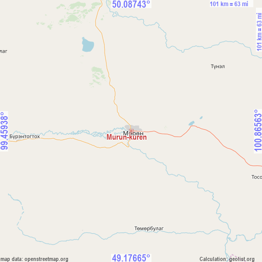
Murun-kuren GPS coordinates[2]
49° 38' 3.012" North, 100° 9' 45" East
| Map corner | latitude | longitude |
|---|---|---|
| Upper-left | 50.08743°, | 99.45938° |
| Center: | 49.63417°, | 100.1625° |
| Lower-right: | 49.17665°, | 100.86563° |
| Map W x H: | 101.3×101.3 km | = 62.9×62.9mi |
| max Lat: | 51.50725° ⇑10.4% North |
| Murun-kuren: | 49.63417° |
| min Lat: | ⇓89.6% South 42.84199° |
| min Long | Murun-kuren | max Long |
| 89.14358° | 100.1625° | 118.51014° |
| W 35.3%⇐ | ⇒64.7% E |
Elevation
Elevation of Murun-kuren is 1280 m = 4199 ft, and this is 136.5 m = 448 ft below average elevation for this country.
| Max E: |
2800 m = 9186 ft | 59.2% |
| Avg. | 1416.5 m = 4647 ft | |
| Murun-kuren | 1280 m = 4199 ft | |
Min E: |
619 m = 2031 ft | 40.8% |
See also: Mongolia elevation on elevation.city.
Geographical zone
Murun-kuren is located in North temperate zone (between Tropic of Cancer and the Arctic Circle). Distance of this North polar circle is 1882.4 km =1169.7 mi to North.| Distance of | km | miles | from Murun-kuren |
|---|---|---|---|
| North Pole | 4488.3 | 2788.9 | to North |
| Arctic Circle | 1882.4 | 1169.7 | to North |
| Tropic Cancer | 2912.9 | 1810 | to South |
| Equator | 5518.8 | 3429.2 | to South |


Nearby cities:
15 places around Murun-kuren: (largest is in red/bold)
• Altraga
104.6 km =65 mi,  305°
305°
• Bayan
46.3 km =28.8 mi,  241°
241°
• Bayantsagaan
109.3 km =67.9 mi,  156°
156°
• Bulag
41.7 km =25.9 mi,  53°
53°
• Eg-Uur
114.2 km =71 mi,  62°
62°
• Erdenet
88.7 km =55.1 mi,  210°
210°
• Ider
98 km =60.9 mi,  192°
192°
• Jargalant
38.2 km =23.7 mi,  169°
169°
• Mandal
60.1 km =37.3 mi,  299°
299°
• Manhan
54.8 km =34.1 mi,  351°
351°
• Rashaant
107.6 km =66.9 mi,  121°
121°
• Selenge
96.7 km =60.1 mi,  103°
103°
• Sharga
99.7 km =62 mi,  280°
280°
• Tsengel
55.2 km =34.3 mi,  108°
108°
• Undur Sume
108.1 km =67.2 mi,  30°
30°
Sources, notices
• [Note1] Compared only with cities in Mongolia existing in our database
• [Src1] Map data: © OpenStreetMap contributors (CC-BY-SA)
• [Src2] Other city data from geonames.org with taken over terms of usage.
• [Src3] Geographical zone / Annual Mean Temperature by Robert A. Rohde @ Wikipedia
