Eg-Uur geodata
Eg-Uur (Hövsgöl) is a seat of a second-order administrative division; located in Mongolia in Asia/Ulaanbaatar (GMT+8) time zone. In our database, there are 33 cities with bigger population. Compared to other cities in Mongolia, 95.7% of cities are located further ↓South; 56.1% of cities are located further →East and 71.2% of cities have higher elevation than Eg-Uur. Note1


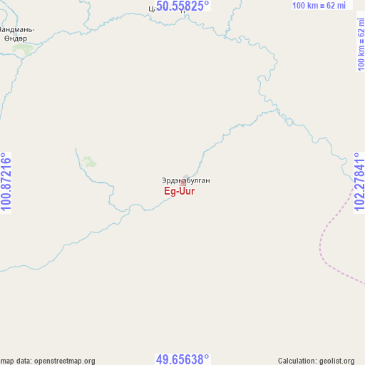
Eg-Uur GPS coordinates[2]
50° 6' 33.984" North, 101° 34' 31.008" East
| Map corner | latitude | longitude |
|---|---|---|
| Upper-left | 50.55825°, | 100.87216° |
| Center: | 50.10944°, | 101.57528° |
| Lower-right: | 49.65638°, | 102.27841° |
| Map W x H: | 100.3×100.3 km | = 62.3×62.3mi |
| max Lat: | 51.50725° ⇑4.3% North |
| Eg-Uur: | 50.10944° |
| min Lat: | ⇓95.7% South 42.84199° |
| min Long | Eg-Uur | max Long |
| 89.14358° | 101.57528° | 118.51014° |
| W 43.9%⇐ | ⇒56.1% E |
Elevation
Elevation of Eg-Uur is 1156 m = 3793 ft, and this is 260.5 m = 855 ft below average elevation for this country.
| Max E: |
2800 m = 9186 ft | 71.2% |
| Avg. | 1416.5 m = 4647 ft | |
| Eg-Uur | 1156 m = 3793 ft | |
Min E: |
619 m = 2031 ft | 28.8% |
See also: Mongolia elevation on elevation.city.
Geographical zone
Eg-Uur is located in North temperate zone (between Tropic of Cancer and the Arctic Circle). Distance of this North polar circle is 1829.5 km =1136.8 mi to North.| Distance of | km | miles | from Eg-Uur |
|---|---|---|---|
| North Pole | 4435.4 | 2756 | to North |
| Arctic Circle | 1829.5 | 1136.8 | to North |
| Tropic Cancer | 2965.7 | 1842.8 | to South |
| Equator | 5571.6 | 3462 | to South |


Nearby cities:
15 places around Eg-Uur: (largest is in red/bold)
• Badrah
62.2 km =38.6 mi,  151°
151°
• Bulag
73.3 km =45.5 mi,  247°
247°
• Bulgan
48.3 km =30 mi,  354°
354°
• Hujirt
138.6 km =86.1 mi,  190°
190°
• Hutag
113 km =70.2 mi,  134°
134°
• Jargalant
131 km =81.4 mi,  226°
226°
• Mandal
154.8 km =96.2 mi,  261°
261°
• Manhan
109.3 km =67.9 mi,  270°
270°
• Murun-kuren
114.2 km =71 mi,  242°
242°
• Rashaant
109.8 km =68.2 mi, 185°
• Selenge
75.6 km =47 mi, 185°
• Sharga
124.3 km =77.2 mi,  162°
162°
• Teshig
79.7 km =49.5 mi,  103°
103°
• Tsengel
85.7 km =53.3 mi,  215°
215°
• Undur Sume
61.2 km =38 mi,  311°
311°
Sources, notices
• [Note1] Compared only with cities in Mongolia existing in our database
• [Src1] Map data: © OpenStreetMap contributors (CC-BY-SA)
• [Src2] Other city data from geonames.org with taken over terms of usage.
• [Src3] Geographical zone / Annual Mean Temperature by Robert A. Rohde @ Wikipedia
