Ider geodata
Ider (Hövsgöl) is a seat of a second-order administrative division; located in Mongolia in Asia/Ulaanbaatar (GMT+8) time zone. In our database, there are 33 cities with bigger population. Compared to other cities in Mongolia, 72.7% of cities are located further ↓South; 66.3% of cities are located further →East and 61% of cities have lower elevation than Ider. Note1


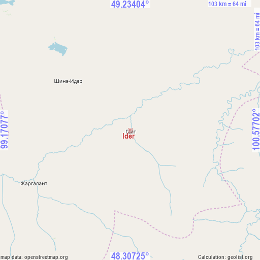
Ider GPS coordinates[2]
48° 46' 22.008" North, 99° 52' 26.004" East
| Map corner | latitude | longitude |
|---|---|---|
| Upper-left | 49.23404°, | 99.17077° |
| Center: | 48.77278°, | 99.87389° |
| Lower-right: | 48.30725°, | 100.57702° |
| Map W x H: | 103×103 km | = 64×64mi |
| max Lat: | 51.50725° ⇑27.3% North |
| Ider: | 48.77278° |
| min Lat: | ⇓72.7% South 42.84199° |
| min Long | Ider | max Long |
| 89.14358° | 99.87389° | 118.51014° |
| W 33.7%⇐ | ⇒66.3% E |
Elevation
Elevation of Ider is 1487 m = 4879 ft, and this is 70.5 m = 231 ft above average elevation for this country.
| Max E: |
2800 m = 9186 ft | 39% |
| Ider | 1487 m 4879 ft | |
| Avg. | 1416.5 m = 4647 ft | |
Min E: |
619 m = 2031 ft | 61% |
See also: Mongolia elevation on elevation.city.
Geographical zone
Ider is located in North temperate zone (between Tropic of Cancer and the Arctic Circle). Distance of this North polar circle is 1978.1 km =1229.1 mi to North.| Distance of | km | miles | from Ider |
|---|---|---|---|
| North Pole | 4584 | 2848.4 | to North |
| Arctic Circle | 1978.1 | 1229.1 | to North |
| Tropic Cancer | 2817.1 | 1750.5 | to South |
| Equator | 5423 | 3369.7 | to South |


Nearby cities:
15 places around Ider: (largest is in red/bold)
• Bayan
76.1 km =47.3 mi,  344°
344°
• Bayan-Uhaa
79.6 km =49.5 mi,  265°
265°
• Bayantsagaan
65.1 km =40.5 mi,  94°
94°
• Erdenet
31.5 km =19.6 mi,  308°
308°
• Horgo
68.1 km =42.3 mi,  179°
179°
• Hujirt
100.7 km =62.6 mi,  83°
83°
• Hunt
105.2 km =65.4 mi,  196°
196°
• Jargalant
64.5 km =40.1 mi,  25°
25°
• Murun-kuren
98 km =60.9 mi,  12°
12°
• Orgil
43.6 km =27.1 mi,  241°
241°
• Teel
93.4 km =58 mi,  149°
149°
• Tosontsengel
116.5 km =72.4 mi, 269°
• Tsahir
107.8 km =67 mi,  224°
224°
• Tsengel
107.8 km =67 mi,  43°
43°
• Öldziyt
113.5 km =70.5 mi,  103°
103°
Sources, notices
• [Note1] Compared only with cities in Mongolia existing in our database
• [Src1] Map data: © OpenStreetMap contributors (CC-BY-SA)
• [Src2] Other city data from geonames.org with taken over terms of usage.
• [Src3] Geographical zone / Annual Mean Temperature by Robert A. Rohde @ Wikipedia
