Jargalant geodata
Jargalant (Hövsgöl) is a seat of a second-order administrative division; located in Mongolia in Asia/Ulaanbaatar (GMT+8) time zone. In our database, there are 33 cities with bigger population. Compared to other cities in Mongolia, 83.4% of cities are located further ↓South; 64.1% of cities are located further →East and 56.1% of cities have lower elevation than Jargalant. Note1


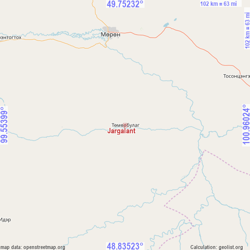
Jargalant GPS coordinates[2]
49° 17' 45.276" North, 100° 15' 25.596" East
| Map corner | latitude | longitude |
|---|---|---|
| Upper-left | 49.75232°, | 99.55399° |
| Center: | 49.29591°, | 100.25711° |
| Lower-right: | 48.83523°, | 100.96024° |
| Map W x H: | 102×102 km | = 63.4×63.4mi |
| max Lat: | 51.50725° ⇑16.6% North |
| Jargalant: | 49.29591° |
| min Lat: | ⇓83.4% South 42.84199° |
| min Long | Jargalant | max Long |
| 89.14358° | 100.25711° | 118.51014° |
| W 35.9%⇐ | ⇒64.1% E |
Elevation
Elevation of Jargalant is 1447 m = 4747 ft, and this is 30.5 m = 100 ft above average elevation for this country.
| Max E: |
2800 m = 9186 ft | 43.9% |
| Jargalant | 1447 m 4747 ft | |
| Avg. | 1416.5 m = 4647 ft | |
Min E: |
619 m = 2031 ft | 56.1% |
See also: Mongolia elevation on elevation.city.
Geographical zone
Jargalant is located in North temperate zone (between Tropic of Cancer and the Arctic Circle). Distance of this North polar circle is 1920 km =1193 mi to North.| Distance of | km | miles | from Jargalant |
|---|---|---|---|
| North Pole | 4525.9 | 2812.3 | to North |
| Arctic Circle | 1920 | 1193 | to North |
| Tropic Cancer | 2875.3 | 1786.6 | to South |
| Equator | 5481.2 | 3405.9 | to South |


Nearby cities:
15 places around Jargalant: (largest is in red/bold)
• Bayan
50 km =31.1 mi,  287°
287°
• Bayantsagaan
72.7 km =45.2 mi,  149°
149°
• Bulag
68.1 km =42.3 mi,  23°
23°
• Erdenet
65.1 km =40.5 mi,  233°
233°
• Hujirt
85.1 km =52.9 mi,  122°
122°
• Ider
64.5 km =40.1 mi,  205°
205°
• Mandal
89.6 km =55.7 mi,  318°
318°
• Manhan
93.1 km =57.8 mi,  350°
350°
• Murun-kuren
38.2 km =23.7 mi, 349°
• Orgil
102.9 km =63.9 mi,  220°
220°
• Rashaant
87.1 km =54.1 mi,  102°
102°
• Selenge
88.9 km =55.2 mi,  80°
80°
• Sharga
119.1 km =74 mi,  298°
298°
• Tsengel
50.1 km =31.1 mi,  66°
66°
• Öldziyt
118.1 km =73.4 mi,  136°
136°
Sources, notices
• [Note1] Compared only with cities in Mongolia existing in our database
• [Src1] Map data: © OpenStreetMap contributors (CC-BY-SA)
• [Src2] Other city data from geonames.org with taken over terms of usage.
• [Src3] Geographical zone / Annual Mean Temperature by Robert A. Rohde @ Wikipedia
