Ereencav geodata
Ereencav (East Aimak) is a seat of a second-order administrative division; located in Mongolia in Asia/Choibalsan (GMT+8) time zone. With population of 23 people, there are 31 cities with bigger population in this country. Compared to other cities in Mongolia, 92.9% of cities are located further ↓South; 99.7% of cities are located further ←West and 99.7% of cities have higher elevation than Ereencav. Note1


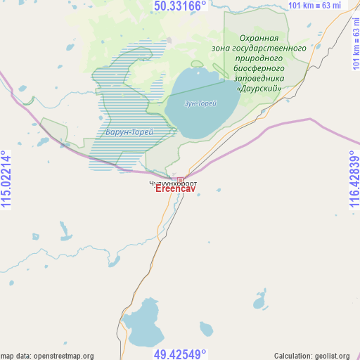
Ereencav GPS coordinates[2]
49° 52' 50.52" North, 115° 43' 30.936" East
| Map corner | latitude | longitude |
|---|---|---|
| Upper-left | 50.33166°, | 115.02214° |
| Center: | 49.8807°, | 115.72526° |
| Lower-right: | 49.42549°, | 116.42839° |
| Map W x H: | 100.8×100.8 km | = 62.6×62.6mi |
| max Lat: | 51.50725° ⇑7.1% North |
| Ereencav: | 49.8807° |
| min Lat: | ⇓92.9% South 42.84199° |
| min Long | Ereencav | max Long |
| 89.14358° | 115.72526° | 118.51014° |
| W 99.7%⇐ | ⇒0.3% E |
Elevation
Elevation of Ereencav is 620 m = 2034 ft, and this is 796.5 m = 2613 ft below average elevation for this country.
| Max E: |
2800 m = 9186 ft | 99.7% |
| Avg. | 1416.5 m = 4647 ft | |
| Ereencav | 620 m = 2034 ft | |
Min E: |
619 m = 2031 ft | 0.3% |
See also: Mongolia elevation on elevation.city.
Geographical zone
Ereencav is located in North temperate zone (between Tropic of Cancer and the Arctic Circle). Distance of this North polar circle is 1855 km =1152.6 mi to North.| Distance of | km | miles | from Ereencav |
|---|---|---|---|
| North Pole | 4460.8 | 2771.8 | to North |
| Arctic Circle | 1855 | 1152.6 | to North |
| Tropic Cancer | 2940.3 | 1827 | to South |
| Equator | 5546.2 | 3446.2 | to South |


Nearby cities:
15 places around Ereencav: (largest is in red/bold)
• Bayan
298 km =185.2 mi,  222°
222°
• Choibalsan
219.1 km =136.1 mi,  203°
203°
• Dashbalbar
102.1 km =63.4 mi,  248°
248°
• Dzüünbulag
327 km =203.2 mi,  185°
185°
• Haylaastay
371.6 km =230.9 mi, 201°
• Hulstay
172.6 km =107.2 mi, 201°
• Javarthushuu
230.7 km =143.4 mi, 249°
• Naranbulag
183.7 km =114.1 mi, 247°
• Sergelen
188.6 km =117.2 mi, 219°
• Sümber
320.4 km =199.1 mi,  140°
140°
• Sümiyn Bulag
103 km =64 mi, 216°
• Tsagaan-Owoo
234.3 km =145.6 mi,  225°
225°
• Tsagaanders
226.4 km =140.7 mi,  205°
205°
• Uldz
301.2 km =187.2 mi,  243°
243°
• Öndörhoshuu
246.7 km =153.3 mi, 212°
Sources, notices
• [Note1] Compared only with cities in Mongolia existing in our database
• [Src1] Map data: © OpenStreetMap contributors (CC-BY-SA)
• [Src2] Other city data from geonames.org with taken over terms of usage.
• [Src3] Geographical zone / Annual Mean Temperature by Robert A. Rohde @ Wikipedia
