Dashbalbar geodata
Dashbalbar (East Aimak) is a seat of a second-order administrative division; located in Mongolia in Asia/Choibalsan (GMT+8) time zone. In our database, there are 33 cities with bigger population. Compared to other cities in Mongolia, 88.3% of cities are located further ↓South; 97.9% of cities are located further ←West and 96.9% of cities have higher elevation than Dashbalbar. Note1


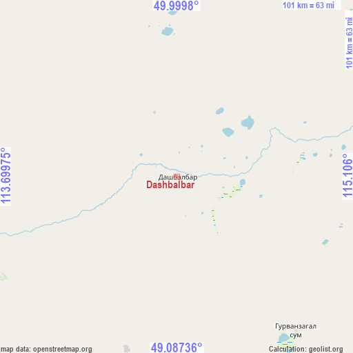
Dashbalbar GPS coordinates[2]
49° 32' 44.556" North, 114° 24' 10.332" East
| Map corner | latitude | longitude |
|---|---|---|
| Upper-left | 49.9998°, | 113.69975° |
| Center: | 49.54571°, | 114.40287° |
| Lower-right: | 49.08736°, | 115.106° |
| Map W x H: | 101.5×101.5 km | = 63.1×63.1mi |
| max Lat: | 51.50725° ⇑11.7% North |
| Dashbalbar: | 49.54571° |
| min Lat: | ⇓88.3% South 42.84199° |
| min Long | Dashbalbar | max Long |
| 89.14358° | 114.40287° | 118.51014° |
| W 97.9%⇐ | ⇒2.1% E |
Elevation
Elevation of Dashbalbar is 707 m = 2320 ft, and this is 709.5 m = 2328 ft below average elevation for this country.
| Max E: |
2800 m = 9186 ft | 96.9% |
| Avg. | 1416.5 m = 4647 ft | |
| Dashbalbar | 707 m = 2320 ft | |
Min E: |
619 m = 2031 ft | 3.1% |
See also: Mongolia elevation on elevation.city.
Geographical zone
Dashbalbar is located in North temperate zone (between Tropic of Cancer and the Arctic Circle). Distance of this North polar circle is 1892.2 km =1175.8 mi to North.| Distance of | km | miles | from Dashbalbar |
|---|---|---|---|
| North Pole | 4498.1 | 2795 | to North |
| Arctic Circle | 1892.2 | 1175.8 | to North |
| Tropic Cancer | 2903 | 1803.8 | to South |
| Equator | 5509 | 3423.1 | to South |


Nearby cities:
15 places around Dashbalbar: (largest is in red/bold)
• Bayan
210.1 km =130.6 mi,  210°
210°
• Bayan
266 km =165.3 mi,  245°
245°
• Bayan-Ovoo
209.3 km =130.1 mi, 253°
• Choibalsan
164.1 km =102 mi,  176°
176°
• Ereencav
102.1 km =63.4 mi,  68°
68°
• Hulstay
128.2 km =79.7 mi,  164°
164°
• Javarthushuu
128.7 km =80 mi, 250°
• Javhlant
258 km =160.3 mi,  220°
220°
• Naranbulag
81.7 km =50.8 mi, 245°
• Sergelen
111.3 km =69.2 mi,  192°
192°
• Sümiyn Bulag
57.6 km =35.8 mi,  142°
142°
• Tsagaan-Owoo
145.7 km =90.5 mi, 209°
• Tsagaanders
166.3 km =103.3 mi, 180°
• Uldz
199.4 km =123.9 mi,  241°
241°
• Öndörhoshuu
175.3 km =108.9 mi, 191°
Sources, notices
• [Note1] Compared only with cities in Mongolia existing in our database
• [Src1] Map data: © OpenStreetMap contributors (CC-BY-SA)
• [Src2] Other city data from geonames.org with taken over terms of usage.
• [Src3] Geographical zone / Annual Mean Temperature by Robert A. Rohde @ Wikipedia
