Dzegstey geodata
Dzegstey (Arhangay) is a seat of a second-order administrative division; located in Mongolia in Asia/Ulaanbaatar (GMT+8) time zone. In our database, there are 33 cities with bigger population. Compared to other cities in Mongolia, 50.3% of cities are located further ↓South; 50.9% of cities are located further →East and 52.5% of cities have higher elevation than Dzegstey. Note1


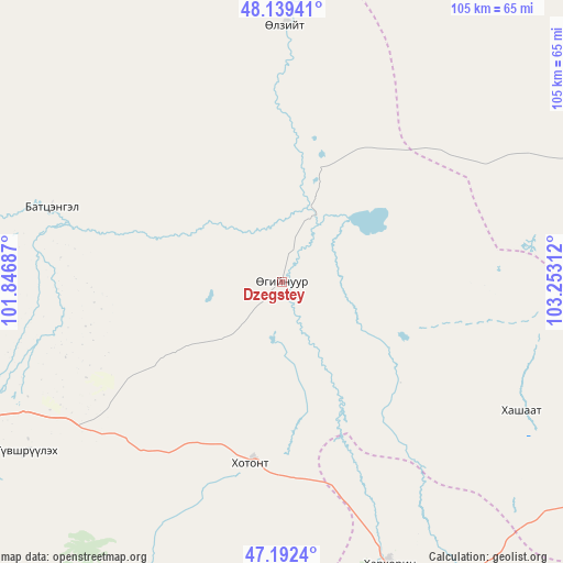
Dzegstey GPS coordinates[2]
47° 40' 4.98" North, 102° 32' 59.964" East
| Map corner | latitude | longitude |
|---|---|---|
| Upper-left | 48.13941°, | 101.84687° |
| Center: | 47.66805°, | 102.54999° |
| Lower-right: | 47.1924°, | 103.25312° |
| Map W x H: | 105.3×105.3 km | = 65.4×65.4mi |
| max Lat: | 51.50725° ⇑49.7% North |
| Dzegstey: | 47.66805° |
| min Lat: | ⇓50.3% South 42.84199° |
| min Long | Dzegstey | max Long |
| 89.14358° | 102.54999° | 118.51014° |
| W 49.1%⇐ | ⇒50.9% E |
Elevation
Elevation of Dzegstey is 1349 m = 4426 ft, and this is 67.5 m = 221 ft below average elevation for this country.
| Max E: |
2800 m = 9186 ft | 52.5% |
| Avg. | 1416.5 m = 4647 ft | |
| Dzegstey | 1349 m = 4426 ft | |
Min E: |
619 m = 2031 ft | 47.5% |
See also: Mongolia elevation on elevation.city.
Geographical zone
Dzegstey is located in North temperate zone (between Tropic of Cancer and the Arctic Circle). Distance of this North polar circle is 2101 km =1305.5 mi to North.| Distance of | km | miles | from Dzegstey |
|---|---|---|---|
| North Pole | 4706.9 | 2924.7 | to North |
| Arctic Circle | 2101 | 1305.5 | to North |
| Tropic Cancer | 2694.3 | 1674.2 | to South |
| Equator | 5300.2 | 3293.4 | to South |


Nearby cities:
15 places around Dzegstey: (largest is in red/bold)
• Altan-Ovoo
64.5 km =40.1 mi,  247°
247°
• Avdzaga
72.5 km =45 mi,  93°
93°
• Bayan
51.1 km =31.8 mi,  118°
118°
• Erhet
74.6 km =46.4 mi,  25°
25°
• Harhorin
56.2 km =34.9 mi,  158°
158°
• Hotont
34.5 km =21.4 mi,  190°
190°
• Höshööt
48.1 km =29.9 mi,  0°
0°
• Jargalant
45.4 km =28.2 mi,  287°
287°
• Kharkhorin
56.5 km =35.1 mi, 159°
• Khujirt
87.3 km =54.2 mi,  169°
169°
• Maanĭt
95.6 km =59.4 mi,  42°
42°
• Tavanbulag
57.7 km =35.9 mi,  236°
236°
• Tsetserleg
85 km =52.8 mi,  255°
255°
• Ulaanshiveet
106.8 km =66.4 mi,  113°
113°
• Övt
97.3 km =60.5 mi, 193°
Sources, notices
• [Note1] Compared only with cities in Mongolia existing in our database
• [Src1] Map data: © OpenStreetMap contributors (CC-BY-SA)
• [Src2] Other city data from geonames.org with taken over terms of usage.
• [Src3] Geographical zone / Annual Mean Temperature by Robert A. Rohde @ Wikipedia
