Hotont geodata
Hotont (Arhangay) is a seat of a second-order administrative division; located in Mongolia in Asia/Ulaanbaatar (GMT+8) time zone. In our database, there are 33 cities with bigger population. Compared to other cities in Mongolia, 55.2% of cities are located further ↑North; 51.5% of cities are located further →East and 57.4% of cities have lower elevation than Hotont. Note1


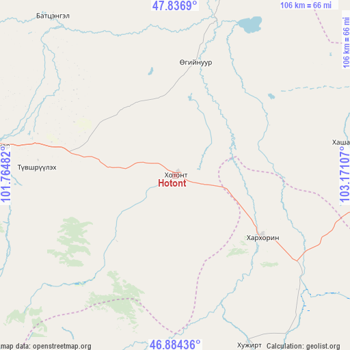
Hotont GPS coordinates[2]
47° 21' 46.008" North, 102° 28' 4.584" East
| Map corner | latitude | longitude |
|---|---|---|
| Upper-left | 47.8369°, | 101.76482° |
| Center: | 47.36278°, | 102.46794° |
| Lower-right: | 46.88436°, | 103.17107° |
| Map W x H: | 105.9×105.9 km | = 65.8×65.8mi |
| max Lat: | 51.50725° ⇑55.2% North |
| Hotont: | 47.36278° |
| min Lat: | ⇓44.8% South 42.84199° |
| min Long | Hotont | max Long |
| 89.14358° | 102.46794° | 118.51014° |
| W 48.5%⇐ | ⇒51.5% E |
Elevation
Elevation of Hotont is 1456 m = 4777 ft, and this is 39.5 m = 130 ft above average elevation for this country.
| Max E: |
2800 m = 9186 ft | 42.6% |
| Hotont | 1456 m 4777 ft | |
| Avg. | 1416.5 m = 4647 ft | |
Min E: |
619 m = 2031 ft | 57.4% |
See also: Mongolia elevation on elevation.city.
Geographical zone
Hotont is located in North temperate zone (between Tropic of Cancer and the Arctic Circle). Distance of this North polar circle is 2134.9 km =1326.6 mi to North.| Distance of | km | miles | from Hotont |
|---|---|---|---|
| North Pole | 4740.8 | 2945.8 | to North |
| Arctic Circle | 2134.9 | 1326.6 | to North |
| Tropic Cancer | 2660.3 | 1653 | to South |
| Equator | 5266.2 | 3272.3 | to South |


Nearby cities:
15 places around Hotont: (largest is in red/bold)
• Altan-Ovoo
54.5 km =33.9 mi,  279°
279°
• Avdzaga
84.3 km =52.4 mi,  69°
69°
• Bayan
52.2 km =32.4 mi,  79°
79°
• Bayan-Ulaan
94 km =58.4 mi,  174°
174°
• Bulagiyn Denj
102 km =63.4 mi,  267°
267°
• Dzegstey
34.5 km =21.4 mi,  10°
10°
• Harhorin
32.5 km =20.2 mi,  124°
124°
• Höshööt
82.3 km =51.1 mi,  4°
4°
• Jargalant
60.6 km =37.7 mi,  322°
322°
• Kharkhorin
32.2 km =20 mi,  126°
126°
• Khujirt
56.6 km =35.2 mi,  156°
156°
• Ongi
100.6 km =62.5 mi,  188°
188°
• Tavanbulag
42.2 km =26.2 mi, 272°
• Tsetserleg
77.3 km =48 mi, 279°
• Övt
62.9 km =39.1 mi,  195°
195°
Sources, notices
• [Note1] Compared only with cities in Mongolia existing in our database
• [Src1] Map data: © OpenStreetMap contributors (CC-BY-SA)
• [Src2] Other city data from geonames.org with taken over terms of usage.
• [Src3] Geographical zone / Annual Mean Temperature by Robert A. Rohde @ Wikipedia
