Sharga geodata
Sharga (Govĭ-Altay) is a seat of a second-order administrative division; located in Mongolia in Asia/Hovd (GMT+7) time zone. In our database, there are 33 cities with bigger population. Compared to other cities in Mongolia, 75.5% of cities are located further ↑North; 82.8% of cities are located further →East and 85.6% of cities have higher elevation than Sharga. Note1


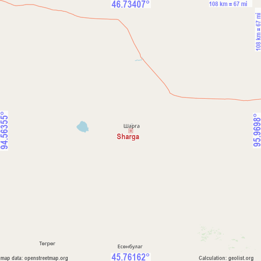
Sharga GPS coordinates[2]
46° 15' 0" North, 95° 16' 0.012" East
| Map corner | latitude | longitude |
|---|---|---|
| Upper-left | 46.73407°, | 94.56355° |
| Center: | 46.25°, | 95.26667° |
| Lower-right: | 45.76162°, | 95.9698° |
| Map W x H: | 108.1×108.1 km | = 67.2×67.2mi |
| max Lat: | 51.50725° ⇑75.5% North |
| Sharga: | 46.25° |
| min Lat: | ⇓24.5% South 42.84199° |
| min Long | Sharga | max Long |
| 89.14358° | 95.26667° | 118.51014° |
| W 17.2%⇐ | ⇒82.8% E |
Elevation
Elevation of Sharga is 998 m = 3274 ft, and this is 418.5 m = 1373 ft below average elevation for this country.
| Max E: |
2800 m = 9186 ft | 85.6% |
| Avg. | 1416.5 m = 4647 ft | |
| Sharga | 998 m = 3274 ft | |
Min E: |
619 m = 2031 ft | 14.4% |
See also: Mongolia elevation on elevation.city.
Geographical zone
Sharga is located in North temperate zone (between Tropic of Cancer and the Arctic Circle). Distance of this North polar circle is 2258.7 km =1403.5 mi to North.| Distance of | km | miles | from Sharga |
|---|---|---|---|
| North Pole | 4864.5 | 3022.7 | to North |
| Arctic Circle | 2258.7 | 1403.5 | to North |
| Tropic Cancer | 2536.6 | 1576.2 | to South |
| Equator | 5142.5 | 3195.4 | to South |


Nearby cities:
15 places around Sharga: (largest is in red/bold)
• Altai
77.4 km =48.1 mi,  79°
79°
• Bayan
82.8 km =51.4 mi,  356°
356°
• Bayangol
104 km =64.6 mi,  222°
222°
• Buga
157 km =97.6 mi,  352°
352°
• Buyanbat
95.3 km =59.2 mi,  31°
31°
• Darvi
91 km =56.5 mi,  284°
284°
• Darvi
147.4 km =91.6 mi,  301°
301°
• Dzüyl
104.9 km =65.2 mi,  273°
273°
• Haliun
77.7 km =48.3 mi,  117°
117°
• Sayn-Ust
135.5 km =84.2 mi,  335°
335°
• Tahilt
146.7 km =91.2 mi,  133°
133°
• Tsagaan-Olom
109.3 km =67.9 mi,  61°
61°
• Tsagaanchuluut
143.8 km =89.4 mi,  48°
48°
• Tseel
89 km =55.3 mi,  148°
148°
• Tögrög
58.3 km =36.2 mi, 216°
Sources, notices
• [Note1] Compared only with cities in Mongolia existing in our database
• [Src1] Map data: © OpenStreetMap contributors (CC-BY-SA)
• [Src2] Other city data from geonames.org with taken over terms of usage.
• [Src3] Geographical zone / Annual Mean Temperature by Robert A. Rohde @ Wikipedia
