Haliun geodata
Haliun (Govĭ-Altay) is a seat of a second-order administrative division; located in Mongolia in Asia/Hovd (GMT+7) time zone. In our database, there are 33 cities with bigger population. Compared to other cities in Mongolia, 80.7% of cities are located further ↑North; 80.4% of cities are located further →East and 55.2% of cities have lower elevation than Haliun. Note1


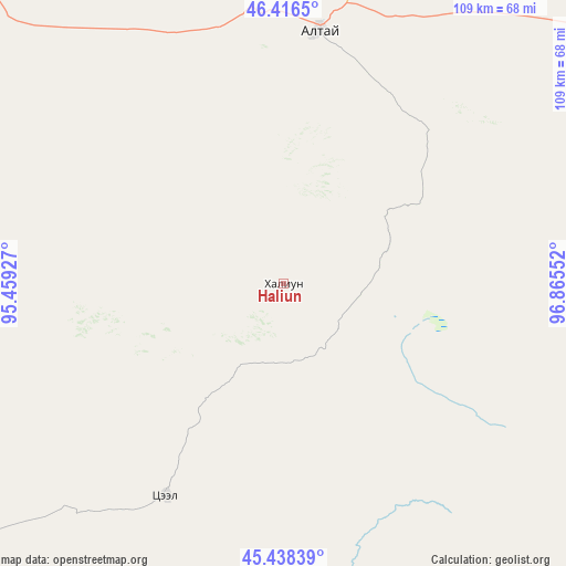
Haliun GPS coordinates[2]
45° 55' 46.56" North, 96° 9' 44.604" East
| Map corner | latitude | longitude |
|---|---|---|
| Upper-left | 46.4165°, | 95.45927° |
| Center: | 45.9296°, | 96.16239° |
| Lower-right: | 45.43839°, | 96.86552° |
| Map W x H: | 108.8×108.8 km | = 67.6×67.6mi |
| max Lat: | 51.50725° ⇑80.7% North |
| Haliun: | 45.9296° |
| min Lat: | ⇓19.3% South 42.84199° |
| min Long | Haliun | max Long |
| 89.14358° | 96.16239° | 118.51014° |
| W 19.6%⇐ | ⇒80.4% E |
Elevation
Elevation of Haliun is 1441 m = 4728 ft, and this is 24.5 m = 80 ft above average elevation for this country.
| Max E: |
2800 m = 9186 ft | 44.8% |
| Haliun | 1441 m 4728 ft | |
| Avg. | 1416.5 m = 4647 ft | |
Min E: |
619 m = 2031 ft | 55.2% |
See also: Mongolia elevation on elevation.city.
Geographical zone
Haliun is located in North temperate zone (between Tropic of Cancer and the Arctic Circle). Distance of this North polar circle is 2294.3 km =1425.6 mi to North.| Distance of | km | miles | from Haliun |
|---|---|---|---|
| North Pole | 4900.2 | 3044.8 | to North |
| Arctic Circle | 2294.3 | 1425.6 | to North |
| Tropic Cancer | 2501 | 1554 | to South |
| Equator | 5106.9 | 3173.3 | to South |


Nearby cities:
15 places around Haliun: (largest is in red/bold)
• Altai
49.8 km =30.9 mi,  8°
8°
• Balgatay
131.8 km =81.9 mi,  35°
35°
• Bayan
139.3 km =86.6 mi,  328°
328°
• Bayangol
145.5 km =90.4 mi,  253°
253°
• Buyanbat
118 km =73.3 mi,  351°
351°
• Jargalant
82.3 km =51.1 mi,  107°
107°
• Sangiyn Dalay
152.1 km =94.5 mi,  125°
125°
• Sharga
77.7 km =48.3 mi,  297°
297°
• Tahilt
74.9 km =46.5 mi,  149°
149°
• Talshand
156.3 km =97.1 mi,  115°
115°
• Taygan
104 km =64.6 mi,  63°
63°
• Tsagaan-Olom
91.5 km =56.9 mi,  17°
17°
• Tsagaanchuluut
137.1 km =85.2 mi, 16°
• Tseel
46.4 km =28.8 mi,  209°
209°
• Tögrög
104.9 km =65.2 mi,  263°
263°
Sources, notices
• [Note1] Compared only with cities in Mongolia existing in our database
• [Src1] Map data: © OpenStreetMap contributors (CC-BY-SA)
• [Src2] Other city data from geonames.org with taken over terms of usage.
• [Src3] Geographical zone / Annual Mean Temperature by Robert A. Rohde @ Wikipedia
