Dzüyl geodata
Dzüyl (Govĭ-Altay) is a seat of a second-order administrative division; located in Mongolia in Asia/Hovd (GMT+7) time zone. In our database, there are 33 cities with bigger population. Compared to other cities in Mongolia, 73.6% of cities are located further ↑North; 86.8% of cities are located further →East and 96.3% of cities have lower elevation than Dzüyl. Note1


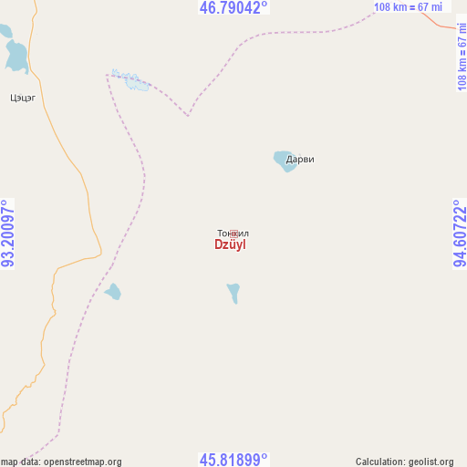
Dzüyl GPS coordinates[2]
46° 18' 24.696" North, 93° 54' 14.724" East
| Map corner | latitude | longitude |
|---|---|---|
| Upper-left | 46.79042°, | 93.20097° |
| Center: | 46.30686°, | 93.90409° |
| Lower-right: | 45.81899°, | 94.60722° |
| Map W x H: | 108×108 km | = 67.1×67.1mi |
| max Lat: | 51.50725° ⇑73.6% North |
| Dzüyl: | 46.30686° |
| min Lat: | ⇓26.4% South 42.84199° |
| min Long | Dzüyl | max Long |
| 89.14358° | 93.90409° | 118.51014° |
| W 13.2%⇐ | ⇒86.8% E |
Elevation
Elevation of Dzüyl is 2206 m = 7238 ft, and this is 789.5 m = 2590 ft above average elevation for this country.
| Max E: |
2800 m = 9186 ft | 3.7% |
| Dzüyl | 2206 m 7238 ft | |
| Avg. | 1416.5 m = 4647 ft | |
Min E: |
619 m = 2031 ft | 96.3% |
See also: Mongolia elevation on elevation.city.
Geographical zone
Dzüyl is located in North temperate zone (between Tropic of Cancer and the Arctic Circle). Distance of this North polar circle is 2252.3 km =1399.5 mi to North.| Distance of | km | miles | from Dzüyl |
|---|---|---|---|
| North Pole | 4858.2 | 3018.7 | to North |
| Arctic Circle | 2252.3 | 1399.5 | to North |
| Tropic Cancer | 2542.9 | 1580.1 | to South |
| Equator | 5148.8 | 3199.3 | to South |


Nearby cities:
15 places around Dzüyl: (largest is in red/bold)
• Altanteel
120.5 km =74.9 mi,  317°
317°
• Altay sumu
137.2 km =85.3 mi,  245°
245°
• Bayan
124.9 km =77.6 mi,  52°
52°
• Bayangol
90.7 km =56.4 mi,  156°
156°
• Buga
171 km =106.3 mi,  29°
29°
• Buyanbat
171.4 km =106.5 mi,  64°
64°
• Darvi
22.8 km =14.2 mi, 45°
• Darvi
73.4 km =45.6 mi,  342°
342°
• Sayn-Ust
126 km =78.3 mi,  21°
21°
• Sharga
104.9 km =65.2 mi,  93°
93°
• Tsenher
152.4 km =94.7 mi,  296°
296°
• Tsetsegnuur
58.7 km =36.5 mi, 303°
• Tögrög
88.1 km =54.7 mi,  127°
127°
• Ulaantolgoy
95.5 km =59.3 mi, 296°
• Uyenchi Somon
148.1 km =92 mi,  258°
258°
Sources, notices
• [Note1] Compared only with cities in Mongolia existing in our database
• [Src1] Map data: © OpenStreetMap contributors (CC-BY-SA)
• [Src2] Other city data from geonames.org with taken over terms of usage.
• [Src3] Geographical zone / Annual Mean Temperature by Robert A. Rohde @ Wikipedia
