Altai geodata
Altai (Govĭ-Altay) is a seat of a first-order administrative division; located in Mongolia in Asia/Hovd (GMT+7) time zone. With population of 15,800 people, there are 18 cities with bigger population in this country. Compared to other cities in Mongolia, 72.4% of cities are located further ↑North; 79.8% of cities are located further →East and 95.4% of cities have lower elevation than Altai. Note1


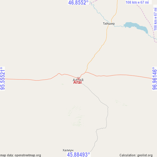
Altai GPS coordinates[2]
46° 22' 19.992" North, 96° 15' 29.988" East
| Map corner | latitude | longitude |
|---|---|---|
| Upper-left | 46.8552°, | 95.55521° |
| Center: | 46.37222°, | 96.25833° |
| Lower-right: | 45.88493°, | 96.96146° |
| Map W x H: | 107.9×107.9 km | = 67×67mi |
| max Lat: | 51.50725° ⇑72.4% North |
| Altai: | 46.37222° |
| min Lat: | ⇓27.6% South 42.84199° |
| min Long | Altai | max Long |
| 89.14358° | 96.25833° | 118.51014° |
| W 20.2%⇐ | ⇒79.8% E |
Elevation
Elevation of Altai is 2156 m = 7073 ft, and this is 739.5 m = 2426 ft above average elevation for this country.
| Max E: |
2800 m = 9186 ft | 4.6% |
| Altai | 2156 m 7073 ft | |
| Avg. | 1416.5 m = 4647 ft | |
Min E: |
619 m = 2031 ft | 95.4% |
See also: Mongolia elevation on elevation.city.
Geographical zone
Altai is located in North temperate zone (between Tropic of Cancer and the Arctic Circle). Distance of this North polar circle is 2245.1 km =1395 mi to North.| Distance of | km | miles | from Altai |
|---|---|---|---|
| North Pole | 4851 | 3014.3 | to North |
| Arctic Circle | 2245.1 | 1395 | to North |
| Tropic Cancer | 2550.2 | 1584.6 | to South |
| Equator | 5156.1 | 3203.9 | to South |


Nearby cities:
15 places around Altai: (largest is in red/bold)
• Aldar
142.8 km =88.7 mi,  8°
8°
• Balgatay
89.9 km =55.9 mi,  49°
49°
• Bayan
106.2 km =66 mi,  310°
310°
• Buyanbat
72 km =44.7 mi,  339°
339°
• Buyant
138.8 km =86.2 mi, 47°
• Haliun
49.8 km =30.9 mi,  188°
188°
• Jargalant
102.2 km =63.5 mi,  136°
136°
• Sharga
77.4 km =48.1 mi,  259°
259°
• Shiree
131.7 km =81.8 mi,  18°
18°
• Tahilt
117.9 km =73.3 mi,  165°
165°
• Taygan
85 km =52.8 mi,  91°
91°
• Tsagaan-Olom
43.1 km =26.8 mi,  28°
28°
• Tsagaanchuluut
88.1 km =54.7 mi, 20°
• Tseel
94.5 km =58.7 mi,  198°
198°
• Tögrög
126.5 km =78.6 mi,  241°
241°
Sources, notices
• [Note1] Compared only with cities in Mongolia existing in our database
• [Src1] Map data: © OpenStreetMap contributors (CC-BY-SA)
• [Src2] Other city data from geonames.org with taken over terms of usage.
• [Src3] Geographical zone / Annual Mean Temperature by Robert A. Rohde @ Wikipedia
