Buyant geodata
Buyant (Hovd) is a seat of a second-order administrative division; located in Mongolia in Asia/Hovd (GMT+7) time zone. In our database, there are 33 cities with bigger population. Compared to other cities in Mongolia, 59.2% of cities are located further ↓South; 93.3% of cities are located further →East and 65.6% of cities have higher elevation than Buyant. Note1


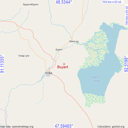
Buyant GPS coordinates[2]
48° 4' 0.012" North, 91° 49' 0.012" East
| Map corner | latitude | longitude |
|---|---|---|
| Upper-left | 48.5344°, | 91.11355° |
| Center: | 48.06667°, | 91.81667° |
| Lower-right: | 47.59465°, | 92.5198° |
| Map W x H: | 104.5×104.5 km | = 64.9×64.9mi |
| max Lat: | 51.50725° ⇑40.8% North |
| Buyant: | 48.06667° |
| min Lat: | ⇓59.2% South 42.84199° |
| min Long | Buyant | max Long |
| 89.14358° | 91.81667° | 118.51014° |
| W 6.7%⇐ | ⇒93.3% E |
Elevation
Elevation of Buyant is 1232 m = 4042 ft, and this is 184.5 m = 605 ft below average elevation for this country.
| Max E: |
2800 m = 9186 ft | 65.6% |
| Avg. | 1416.5 m = 4647 ft | |
| Buyant | 1232 m = 4042 ft | |
Min E: |
619 m = 2031 ft | 34.4% |
See also: Mongolia elevation on elevation.city.
Geographical zone
Buyant is located in North temperate zone (between Tropic of Cancer and the Arctic Circle). Distance of this North polar circle is 2056.7 km =1278 mi to North.| Distance of | km | miles | from Buyant |
|---|---|---|---|
| North Pole | 4662.5 | 2897.1 | to North |
| Arctic Circle | 2056.7 | 1278 | to North |
| Tropic Cancer | 2738.6 | 1701.7 | to South |
| Equator | 5344.5 | 3320.9 | to South |


Nearby cities:
15 places around Buyant: (largest is in red/bold)
• Altanteel
131.3 km =81.6 mi,  144°
144°
• Bayanhoshuu
20 km =12.4 mi,  21°
21°
• Duut
62.7 km =39 mi,  192°
192°
• Har-Us
54.3 km =33.7 mi,  328°
328°
• Har-Us
108.7 km =67.5 mi,  8°
8°
• Jargalant
138.1 km =85.8 mi,  203°
203°
• Khovd
14.7 km =9.1 mi,  242°
242°
• Namir
115.8 km =72 mi,  356°
356°
• Rashaant
80.5 km =50 mi,  245°
245°
• Sharbulag
126.2 km =78.4 mi,  48°
48°
• Tolbo
120 km =74.6 mi,  288°
288°
• Tsenher
129.8 km =80.7 mi,  170°
170°
• Tögrög
77.7 km =48.3 mi,  156°
156°
• Ulaan Khat
147.2 km =91.5 mi,  266°
266°
• Urdgol
67.3 km =41.8 mi,  112°
112°
Sources, notices
• [Note1] Compared only with cities in Mongolia existing in our database
• [Src1] Map data: © OpenStreetMap contributors (CC-BY-SA)
• [Src2] Other city data from geonames.org with taken over terms of usage.
• [Src3] Geographical zone / Annual Mean Temperature by Robert A. Rohde @ Wikipedia
