Khovd geodata
Khovd (Hovd) is a seat of a first-order administrative division; located in Mongolia in Asia/Hovd (GMT+7) time zone. With population of 30,500 people, there are 3 cities with bigger population in this country. Compared to other cities in Mongolia, 57.7% of cities are located further ↓South; 94.2% of cities are located further →East and 50.9% of cities have lower elevation than Khovd. Note1


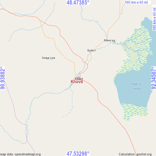
Khovd GPS coordinates[2]
48° 0' 20.016" North, 91° 38' 30.984" East
| Map corner | latitude | longitude |
|---|---|---|
| Upper-left | 48.47385°, | 90.93882° |
| Center: | 48.00556°, | 91.64194° |
| Lower-right: | 47.53298°, | 92.34507° |
| Map W x H: | 104.6×104.6 km | = 65×65mi |
| max Lat: | 51.50725° ⇑42.3% North |
| Khovd: | 48.00556° |
| min Lat: | ⇓57.7% South 42.84199° |
| min Long | Khovd | max Long |
| 89.14358° | 91.64194° | 118.51014° |
| W 5.8%⇐ | ⇒94.2% E |
Elevation
Elevation of Khovd is 1395 m = 4577 ft, and this is 21.5 m = 71 ft below average elevation for this country.
| Max E: |
2800 m = 9186 ft | 49.1% |
| Avg. | 1416.5 m = 4647 ft | |
| Khovd | 1395 m = 4577 ft | |
Min E: |
619 m = 2031 ft | 50.9% |
See also: Mongolia elevation on elevation.city.
Geographical zone
Khovd is located in North temperate zone (between Tropic of Cancer and the Arctic Circle). Distance of this North polar circle is 2063.5 km =1282.2 mi to North.| Distance of | km | miles | from Khovd |
|---|---|---|---|
| North Pole | 4669.3 | 2901.4 | to North |
| Arctic Circle | 2063.5 | 1282.2 | to North |
| Tropic Cancer | 2731.8 | 1697.5 | to South |
| Equator | 5337.7 | 3316.7 | to South |


Nearby cities:
15 places around Khovd: (largest is in red/bold)
• Altanteel
134.3 km =83.5 mi,  137°
137°
• Bayanhoshuu
32.5 km =20.2 mi,  38°
38°
• Buyant
14.7 km =9.1 mi,  62°
62°
• Duut
54.4 km =33.8 mi,  180°
180°
• Har-Us
55.3 km =34.4 mi,  343°
343°
• Har-Us
117.9 km =73.3 mi,  14°
14°
• Jargalant
127 km =78.9 mi,  199°
199°
• Namir
122.5 km =76.1 mi,  2°
2°
• Rashaant
65.9 km =40.9 mi,  246°
246°
• Sharbulag
140.4 km =87.2 mi,  50°
50°
• Tolbo
110.6 km =68.7 mi,  294°
294°
• Tsenher
126.2 km =78.4 mi,  163°
163°
• Tögrög
78 km =48.5 mi,  146°
146°
• Ulaan Khat
134 km =83.3 mi,  268°
268°
• Urdgol
77.5 km =48.2 mi,  104°
104°
Sources, notices
• [Note1] Compared only with cities in Mongolia existing in our database
• [Src1] Map data: © OpenStreetMap contributors (CC-BY-SA)
• [Src2] Other city data from geonames.org with taken over terms of usage.
• [Src3] Geographical zone / Annual Mean Temperature by Robert A. Rohde @ Wikipedia
