Bulgan geodata
Bulgan (Bayanhongor) is a seat of a second-order administrative division; located in Mongolia in Asia/Ulaanbaatar (GMT+8) time zone. In our database, there are 33 cities with bigger population. Compared to other cities in Mongolia, 91.4% of cities are located further ↑North; 72.1% of cities are located further →East and 99.4% of cities have lower elevation than Bulgan. Note1


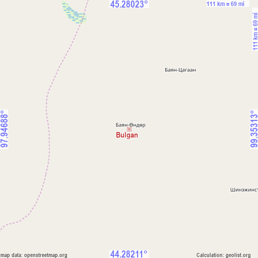
Bulgan GPS coordinates[2]
44° 46' 59.988" North, 98° 39' 0" East
| Map corner | latitude | longitude |
|---|---|---|
| Upper-left | 45.28023°, | 97.94688° |
| Center: | 44.78333°, | 98.65° |
| Lower-right: | 44.28211°, | 99.35313° |
| Map W x H: | 111×111 km | = 69×69mi |
| max Lat: | 51.50725° ⇑91.4% North |
| Bulgan: | 44.78333° |
| min Lat: | ⇓8.6% South 42.84199° |
| min Long | Bulgan | max Long |
| 89.14358° | 98.65° | 118.51014° |
| W 27.9%⇐ | ⇒72.1% E |
Elevation
Elevation of Bulgan is 2467 m = 8094 ft, and this is 1050.5 m = 3447 ft above average elevation for this country.
| Max E: |
2800 m = 9186 ft | 0.59999999999999% |
| Bulgan | 2467 m 8094 ft | |
| Avg. | 1416.5 m = 4647 ft | |
Min E: |
619 m = 2031 ft | 99.4% |
See also: Mongolia elevation on elevation.city.
Geographical zone
Bulgan is located in North temperate zone (between Tropic of Cancer and the Arctic Circle). Distance of this Northern Tropic circle is 2373.5 km =1474.8 mi to South.| Distance of | km | miles | from Bulgan |
|---|---|---|---|
| North Pole | 5027.6 | 3124 | to North |
| Arctic Circle | 2421.7 | 1504.8 | to North |
| Tropic Cancer | 2373.5 | 1474.8 | to South |
| Equator | 4979.4 | 3094.1 | to South |


Nearby cities:
15 places around Bulgan: (largest is in red/bold)
• Bayansayr
105.5 km =65.6 mi,  35°
35°
• Bodĭ
166.4 km =103.4 mi,  65°
65°
• Buyant
153.8 km =95.6 mi,  1°
1°
• Delgermörön
183 km =113.7 mi,  351°
351°
• Dzadgay
175.1 km =108.8 mi,  24°
24°
• Dzalaa
56.1 km =34.9 mi,  119°
119°
• Hatansuudal
174.2 km =108.2 mi,  98°
98°
• Horiult
172.8 km =107.4 mi, 74°
• Höhbürd
218 km =135.5 mi, 39°
• Jargalant
154.7 km =96.1 mi,  311°
311°
• Sangiyn Dalay
80.8 km =50.2 mi,  298°
298°
• Tahilt
169.4 km =105.3 mi,  291°
291°
• Talshand
80.5 km =50 mi,  319°
319°
• Taygan
201.2 km =125 mi,  330°
330°
• Örgön
137.6 km =85.5 mi,  92°
92°
Sources, notices
• [Note1] Compared only with cities in Mongolia existing in our database
• [Src1] Map data: © OpenStreetMap contributors (CC-BY-SA)
• [Src2] Other city data from geonames.org with taken over terms of usage.
• [Src3] Geographical zone / Annual Mean Temperature by Robert A. Rohde @ Wikipedia
