Taygan geodata
Taygan (Govĭ-Altay) is a seat of a second-order administrative division; located in Mongolia in Asia/Hovd (GMT+7) time zone. In our database, there are 33 cities with bigger population. Compared to other cities in Mongolia, 73.3% of cities are located further ↑North; 75.5% of cities are located further →East and 80.1% of cities have lower elevation than Taygan. Note1


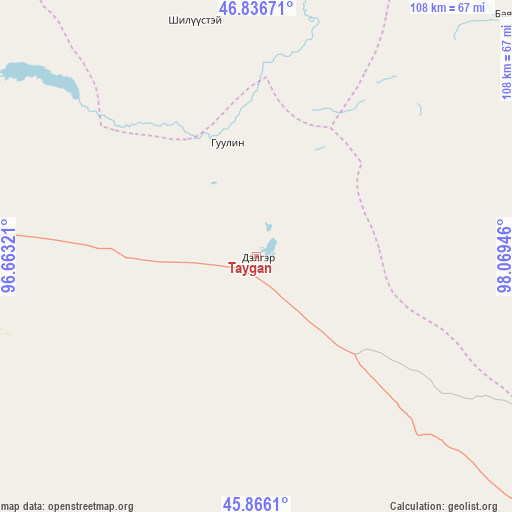
Taygan GPS coordinates[2]
46° 21' 12.816" North, 97° 21' 58.788" East
| Map corner | latitude | longitude |
|---|---|---|
| Upper-left | 46.83671°, | 96.66321° |
| Center: | 46.35356°, | 97.36633° |
| Lower-right: | 45.8661°, | 98.06946° |
| Map W x H: | 107.9×107.9 km | = 67×67mi |
| max Lat: | 51.50725° ⇑73.3% North |
| Taygan: | 46.35356° |
| min Lat: | ⇓26.7% South 42.84199° |
| min Long | Taygan | max Long |
| 89.14358° | 97.36633° | 118.51014° |
| W 24.5%⇐ | ⇒75.5% E |
Elevation
Elevation of Taygan is 1797 m = 5896 ft, and this is 380.5 m = 1248 ft above average elevation for this country.
| Max E: |
2800 m = 9186 ft | 19.9% |
| Taygan | 1797 m 5896 ft | |
| Avg. | 1416.5 m = 4647 ft | |
Min E: |
619 m = 2031 ft | 80.1% |
See also: Mongolia elevation on elevation.city.
Geographical zone
Taygan is located in North temperate zone (between Tropic of Cancer and the Arctic Circle). Distance of this North polar circle is 2247.1 km =1396.3 mi to North.| Distance of | km | miles | from Taygan |
|---|---|---|---|
| North Pole | 4853 | 3015.5 | to North |
| Arctic Circle | 2247.1 | 1396.3 | to North |
| Tropic Cancer | 2548.1 | 1583.3 | to South |
| Equator | 5154 | 3202.5 | to South |


Nearby cities:
15 places around Taygan: (largest is in red/bold)
• Altai
85 km =52.8 mi,  271°
271°
• Balgatay
63 km =39.1 mi,  344°
344°
• Bayanbulag
75.1 km =46.7 mi,  47°
47°
• Buyanbat
130.1 km =80.8 mi,  302°
302°
• Buyant
97.2 km =60.4 mi,  10°
10°
• Buyant
104 km =64.6 mi,  101°
101°
• Delgermörön
70.9 km =44.1 mi,  84°
84°
• Haliun
104 km =64.6 mi,  243°
243°
• Höviyn Am
133.9 km =83.2 mi,  43°
43°
• Jargalant
73.1 km =45.4 mi,  191°
191°
• Shiree
134.2 km =83.4 mi, 341°
• Tahilt
125.1 km =77.7 mi,  206°
206°
• Talshand
123.1 km =76.5 mi,  157°
157°
• Tsagaan-Olom
75.7 km =47 mi, 301°
• Tsagaanchuluut
99.6 km =61.9 mi,  327°
327°
Sources, notices
• [Note1] Compared only with cities in Mongolia existing in our database
• [Src1] Map data: © OpenStreetMap contributors (CC-BY-SA)
• [Src2] Other city data from geonames.org with taken over terms of usage.
• [Src3] Geographical zone / Annual Mean Temperature by Robert A. Rohde @ Wikipedia
