Maafushi geodata
Maafushi (Kaafu Atoll) is a populated place; located in Maldives in Indian/Maldives (GMT+5) time zone. With population of 3,000 people, there are 8 cities with bigger population in this country. Compared to other cities in Maldives, 64.3% of cities are located further ↓South; 82.1% of cities are located further ←West and 85.7% of cities have higher elevation than Maafushi. Note1


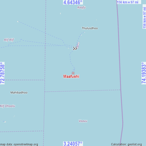
Maafushi GPS coordinates[2]
3° 56' 32.316" North, 73° 29' 26.52" East
| Map corner | latitude | longitude |
|---|---|---|
| Upper-left | 4.64346°, | 72.78758° |
| Center: | 3.94231°, | 73.4907° |
| Lower-right: | 3.24057°, | 74.19383° |
| Map W x H: | 156×156 km | = 96.9×96.9mi |
| max Lat: | 6.88744° ⇑35.7% North |
| Maafushi: | 3.94231° |
| min Lat: | ⇓64.3% South -0.6° |
| min Long | Maafushi | max Long |
| 72.89437° | 73.4907° | 73.56667° |
| W 82.1%⇐ | ⇒17.9% E |
Elevation
Elevation of Maafushi is 6 m = 20 ft, and this is 1.3 m = 4 ft below average elevation for this country.
| Max E: |
12 m = 39 ft | 85.7% |
| Avg. | 7.3 m = 24 ft | |
| Maafushi | 6 m = 20 ft | |
Min E: |
-1 m = -3 ft | 14.3% |
See also: Maldives elevation on elevation.city.
Geographical zone
Maafushi is located in North Torrid zone (between Equator and Tropic of Cancer). Distance of Equator is 438.3 km =272.3 mi to South.| Distance of | km | miles | from Maafushi |
|---|---|---|---|
| North Pole | 9568.7 | 5945.7 | to North |
| Arctic Circle | 6962.8 | 4326.5 | to North |
| Tropic Cancer | 2167.6 | 1346.9 | to North |
| Equator | 438.3 | 272.3 | to South |


Nearby cities:
15 places around Maafushi: (largest is in red/bold)
• Buruni
159.6 km =99.2 mi,  195°
195°
• Diyamigili
178.9 km =111.2 mi,  185°
185°
• Eydhafushi
137.2 km =85.3 mi,  340°
340°
• Felidhoo
52.7 km =32.7 mi,  173°
173°
• Guraidhoo
5.4 km =3.4 mi,  210°
210°
• Guraidhoo
180.9 km =112.4 mi, 186°
• Hulhumale
30.4 km =18.9 mi,  10°
10°
• Kudahuvadhoo
156.1 km =97 mi, 205°
• Madifushi
177 km =110 mi,  184°
184°
• Mahibadhoo
61.4 km =38.2 mi,  250°
250°
• Male
26 km =16.2 mi,  4°
4°
• Muli
114.4 km =71.1 mi, 175°
• Naifaru
167.6 km =104.1 mi,  355°
355°
• Open Stage
137.4 km =85.4 mi, 340°
• Vilufushi
161.3 km =100.2 mi, 187°
Sources, notices
• [Note1] Compared only with cities in Maldives existing in our database
• [Src1] Map data: © OpenStreetMap contributors (CC-BY-SA)
• [Src2] Other city data from geonames.org with taken over terms of usage.
• [Src3] Geographical zone / Annual Mean Temperature by Robert A. Rohde @ Wikipedia
