Madifushi geodata
Madifushi is a populated place; located in Maldives in Indian/Maldives (GMT+5) time zone. With population of 1,110 people, there are 22 cities with bigger population in this country. Compared to other cities in Maldives, 64.3% of cities are located further ↑North; 57.1% of cities are located further ←West and 60.7% of cities have lower elevation than Madifushi. Note1


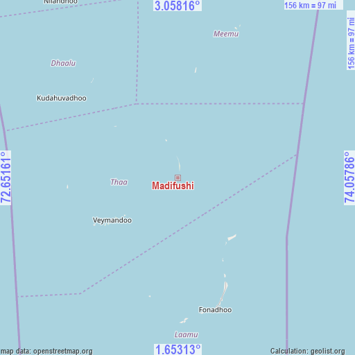
Madifushi GPS coordinates[2]
2° 21' 20.952" North, 73° 21' 17.028" East
| Map corner | latitude | longitude |
|---|---|---|
| Upper-left | 3.05816°, | 72.65161° |
| Center: | 2.35582°, | 73.35473° |
| Lower-right: | 1.65313°, | 74.05786° |
| Map W x H: | 156.2×156.2 km | = 97.1×97.1mi |
| max Lat: | 6.88744° ⇑64.3% North |
| Madifushi: | 2.35582° |
| min Lat: | ⇓35.7% South -0.6° |
| min Long | Madifushi | max Long |
| 72.89437° | 73.35473° | 73.56667° |
| W 57.1%⇐ | ⇒42.9% E |
Elevation
Elevation of Madifushi is 9 m = 30 ft, and this is 1.7 m = 6 ft above average elevation for this country.
| Max E: |
12 m = 39 ft | 39.3% |
| Madifushi | 9 m 30 ft | |
| Avg. | 7.3 m = 24 ft | |
Min E: |
-1 m = -3 ft | 60.7% |
See also: Maldives elevation on elevation.city.
Geographical zone
Madifushi is located in North Torrid zone (between Equator and Tropic of Cancer). Distance of Equator is 261.9 km =162.7 mi to South.| Distance of | km | miles | from Madifushi |
|---|---|---|---|
| North Pole | 9745.1 | 6055.3 | to North |
| Arctic Circle | 7139.2 | 4436.1 | to North |
| Tropic Cancer | 2344 | 1456.5 | to North |
| Equator | 261.9 | 162.7 | to South |


Nearby cities:
15 places around Madifushi: (largest is in red/bold)
• Buruni
35.6 km =22.1 mi,  309°
309°
• Diyamigili
2.5 km =1.6 mi,  226°
226°
• Felidhoo
125.9 km =78.2 mi,  9°
9°
• Fonadhoo
60.5 km =37.6 mi,  164°
164°
• Guraidhoo
5.3 km =3.3 mi, 229°
• Guraidhoo
172.2 km =107 mi,  4°
4°
• Hithadhoo
62.3 km =38.7 mi,  176°
176°
• Kudahuvadhoo
62 km =38.5 mi,  304°
304°
• Maafushi
177 km =110 mi, 4°
• Mahibadhoo
161.6 km =100.4 mi,  344°
344°
• Male
203 km =126.1 mi, 4°
• Muli
66.7 km =41.4 mi,  20°
20°
• Veymandoo
34.3 km =21.3 mi,  237°
237°
• Viligili
177.8 km =110.5 mi, 177°
• Vilufushi
17.2 km =10.7 mi, 342°
Sources, notices
• [Note1] Compared only with cities in Maldives existing in our database
• [Src1] Map data: © OpenStreetMap contributors (CC-BY-SA)
• [Src2] Other city data from geonames.org with taken over terms of usage.
• [Src3] Geographical zone / Annual Mean Temperature by Robert A. Rohde @ Wikipedia
