Vilufushi geodata
Vilufushi is a populated place; located in Maldives in Indian/Maldives (GMT+5) time zone. With population of 2,077 people, there are 13 cities with bigger population in this country. Compared to other cities in Maldives, 60.7% of cities are located further ↑North; 53.6% of cities are located further →East and 71.4% of cities have higher elevation than Vilufushi. Note1


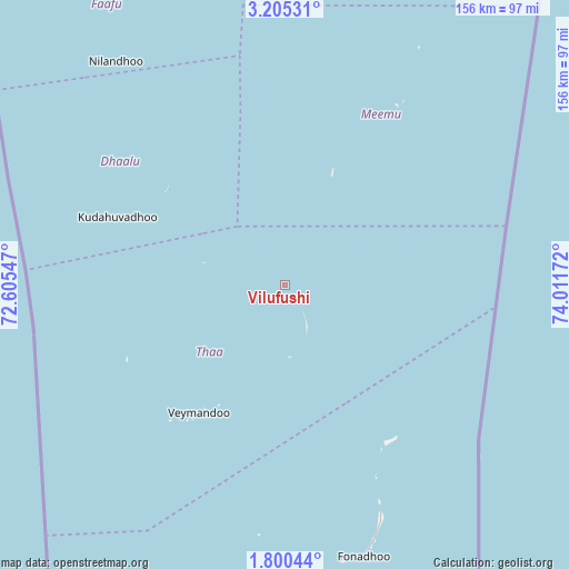
Vilufushi GPS coordinates[2]
2° 30' 11.016" North, 73° 18' 30.924" East
| Map corner | latitude | longitude |
|---|---|---|
| Upper-left | 3.20531°, | 72.60547° |
| Center: | 2.50306°, | 73.30859° |
| Lower-right: | 1.80044°, | 74.01172° |
| Map W x H: | 156.2×156.2 km | = 97.1×97.1mi |
| max Lat: | 6.88744° ⇑60.7% North |
| Vilufushi: | 2.50306° |
| min Lat: | ⇓39.3% South -0.6° |
| min Long | Vilufushi | max Long |
| 72.89437° | 73.30859° | 73.56667° |
| W 46.4%⇐ | ⇒53.6% E |
Elevation
Elevation of Vilufushi is 7 m = 23 ft, and this is 0.3 m = 1 ft below average elevation for this country.
| Max E: |
12 m = 39 ft | 71.4% |
| Avg. | 7.3 m = 24 ft | |
| Vilufushi | 7 m = 23 ft | |
Min E: |
-1 m = -3 ft | 28.6% |
See also: Maldives elevation on elevation.city.
Geographical zone
Vilufushi is located in North Torrid zone (between Equator and Tropic of Cancer). Distance of Equator is 278.3 km =172.9 mi to South.| Distance of | km | miles | from Vilufushi |
|---|---|---|---|
| North Pole | 9728.7 | 6045.1 | to North |
| Arctic Circle | 7122.9 | 4426 | to North |
| Tropic Cancer | 2327.6 | 1446.3 | to North |
| Equator | 278.3 | 172.9 | to South |


Nearby cities:
15 places around Vilufushi: (largest is in red/bold)
• Buruni
23.2 km =14.4 mi,  285°
285°
• Diyamigili
18.4 km =11.4 mi,  169°
169°
• Felidhoo
110.9 km =68.9 mi,  13°
13°
• Fonadhoo
77.6 km =48.2 mi,  163°
163°
• Guraidhoo
19.9 km =12.4 mi,  176°
176°
• Guraidhoo
156.4 km =97.2 mi, 6°
• Hithadhoo
79 km =49.1 mi, 173°
• Hulhumale
191.7 km =119.1 mi, 7°
• Kudahuvadhoo
49.6 km =30.8 mi, 292°
• Maafushi
161.3 km =100.2 mi, 7°
• Madifushi
17.2 km =10.7 mi, 162°
• Mahibadhoo
144.4 km =89.7 mi,  344°
344°
• Male
187.3 km =116.4 mi, 6°
• Muli
54.2 km =33.7 mi,  31°
31°
• Veymandoo
42.3 km =26.3 mi,  214°
214°
Sources, notices
• [Note1] Compared only with cities in Maldives existing in our database
• [Src1] Map data: © OpenStreetMap contributors (CC-BY-SA)
• [Src2] Other city data from geonames.org with taken over terms of usage.
• [Src3] Geographical zone / Annual Mean Temperature by Robert A. Rohde @ Wikipedia
