Buruni geodata
Buruni (Dhaalu Atholhu) is a populated place; located in Maldives in Indian/Maldives (GMT+5) time zone. With population of 577 people, there are 27 cities with bigger population in this country. Compared to other cities in Maldives, 57.1% of cities are located further ↑North; 67.9% of cities are located further →East and 60.7% of cities have lower elevation than Buruni. Note1


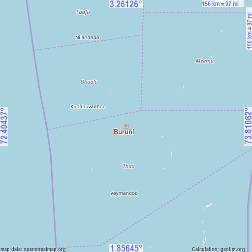
Buruni GPS coordinates[2]
2° 33' 32.58" North, 73° 6' 26.964" East
| Map corner | latitude | longitude |
|---|---|---|
| Upper-left | 3.26126°, | 72.40437° |
| Center: | 2.55905°, | 73.10749° |
| Lower-right: | 1.85645°, | 73.81062° |
| Map W x H: | 156.2×156.2 km | = 97.1×97.1mi |
| max Lat: | 6.88744° ⇑57.1% North |
| Buruni: | 2.55905° |
| min Lat: | ⇓42.9% South -0.6° |
| min Long | Buruni | max Long |
| 72.89437° | 73.10749° | 73.56667° |
| W 32.1%⇐ | ⇒67.9% E |
Elevation
Elevation of Buruni is 9 m = 30 ft, and this is 1.7 m = 6 ft above average elevation for this country.
| Max E: |
12 m = 39 ft | 39.3% |
| Buruni | 9 m 30 ft | |
| Avg. | 7.3 m = 24 ft | |
Min E: |
-1 m = -3 ft | 60.7% |
See also: Maldives elevation on elevation.city.
Geographical zone
Buruni is located in North Torrid zone (between Equator and Tropic of Cancer). Distance of Equator is 284.5 km =176.8 mi to South.| Distance of | km | miles | from Buruni |
|---|---|---|---|
| North Pole | 9722.5 | 6041.3 | to North |
| Arctic Circle | 7116.6 | 4422 | to North |
| Tropic Cancer | 2321.4 | 1442.5 | to North |
| Equator | 284.5 | 176.8 | to South |


Nearby cities:
15 places around Buruni: (largest is in red/bold)
• Diyamigili
35.4 km =22 mi,  133°
133°
• Felidhoo
112.6 km =70 mi,  25°
25°
• Fonadhoo
91.9 km =57.1 mi,  151°
151°
• Guraidhoo
35 km =21.7 mi,  138°
138°
• Guraidhoo
154.4 km =95.9 mi,  14°
14°
• Hithadhoo
90.3 km =56.1 mi,  159°
159°
• Hulhumale
189.9 km =118 mi, 14°
• Kudahuvadhoo
26.7 km =16.6 mi,  297°
297°
• Maafushi
159.6 km =99.2 mi,  15°
15°
• Madifushi
35.6 km =22.1 mi, 129°
• Mahibadhoo
134.1 km =83.3 mi,  353°
353°
• Male
185.1 km =115 mi, 13°
• Muli
64.7 km =40.2 mi,  52°
52°
• Veymandoo
41.3 km =25.7 mi,  181°
181°
• Vilufushi
23.2 km =14.4 mi,  105°
105°
Sources, notices
• [Note1] Compared only with cities in Maldives existing in our database
• [Src1] Map data: © OpenStreetMap contributors (CC-BY-SA)
• [Src2] Other city data from geonames.org with taken over terms of usage.
• [Src3] Geographical zone / Annual Mean Temperature by Robert A. Rohde @ Wikipedia
