Eydhafushi geodata
Eydhafushi (Baa Atholhu) is a seat of a first-order administrative division; located in Maldives in Indian/Maldives (GMT+5) time zone. With population of 2,808 people, there are 11 cities with bigger population in this country. Compared to other cities in Maldives, 75% of cities are located further ↓South; 82.1% of cities are located further →East and 71.4% of cities have higher elevation than Eydhafushi. Note1


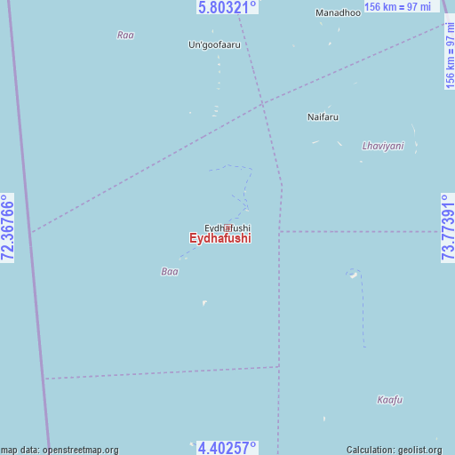
Eydhafushi GPS coordinates[2]
5° 6' 11.772" North, 73° 4' 14.808" East
| Map corner | latitude | longitude |
|---|---|---|
| Upper-left | 5.80321°, | 72.36766° |
| Center: | 5.10327°, | 73.07078° |
| Lower-right: | 4.40257°, | 73.77391° |
| Map W x H: | 155.7×155.7 km | = 96.7×96.7mi |
| max Lat: | 6.88744° ⇑25% North |
| Eydhafushi: | 5.10327° |
| min Lat: | ⇓75% South -0.6° |
| min Long | Eydhafushi | max Long |
| 72.89437° | 73.07078° | 73.56667° |
| W 17.9%⇐ | ⇒82.1% E |
Elevation
Elevation of Eydhafushi is 7 m = 23 ft, and this is 0.3 m = 1 ft below average elevation for this country.
| Max E: |
12 m = 39 ft | 71.4% |
| Avg. | 7.3 m = 24 ft | |
| Eydhafushi | 7 m = 23 ft | |
Min E: |
-1 m = -3 ft | 28.6% |
See also: Maldives elevation on elevation.city.
Geographical zone
Eydhafushi is located in North Torrid zone (between Equator and Tropic of Cancer). Distance of Equator is 567.4 km =352.6 mi to South.| Distance of | km | miles | from Eydhafushi |
|---|---|---|---|
| North Pole | 9439.6 | 5865.5 | to North |
| Arctic Circle | 6833.7 | 4246.3 | to North |
| Tropic Cancer | 2038.5 | 1266.7 | to North |
| Equator | 567.4 | 352.6 | to South |


Nearby cities:
15 places around Eydhafushi: (largest is in red/bold)
• Dhidhdhoo
198.4 km =123.3 mi,  1°
1°
• Felidhoo
188.9 km =117.4 mi,  163°
163°
• Funadhoo
119 km =73.9 mi,  11°
11°
• Guraidhoo
140.7 km =87.4 mi, 161°
• Hulhumale
111.9 km =69.5 mi,  152°
152°
• Kudahuvadhoo
271.2 km =168.5 mi,  184°
184°
• Kulhudhuffushi
168.9 km =104.9 mi,  359°
359°
• Maafushi
137.2 km =85.3 mi, 160°
• Mahibadhoo
150.1 km =93.3 mi, 184°
• Male
114.1 km =70.9 mi, 154°
• Manadhoo
83 km =51.6 mi,  27°
27°
• Muli
249.3 km =154.9 mi,  167°
167°
• Naifaru
50 km =31.1 mi,  40°
40°
• Open Stage
0.2 km =0.1 mi, 10°
• Ugoofaaru
63 km =39.1 mi, 355°
Sources, notices
• [Note1] Compared only with cities in Maldives existing in our database
• [Src1] Map data: © OpenStreetMap contributors (CC-BY-SA)
• [Src2] Other city data from geonames.org with taken over terms of usage.
• [Src3] Geographical zone / Annual Mean Temperature by Robert A. Rohde @ Wikipedia
