Guraidhoo geodata
Guraidhoo is a populated place; located in Maldives in Indian/Maldives (GMT+5) time zone. With population of 1,800 people, there are 14 cities with bigger population in this country. Compared to other cities in Maldives, 71.4% of cities are located further ↑North; 50% of cities are located further ←West and 96.4% of cities have lower elevation than Guraidhoo. Note1


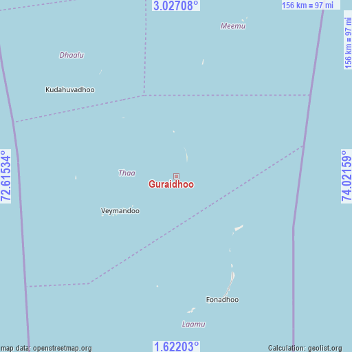
Guraidhoo GPS coordinates[2]
2° 19' 29.028" North, 73° 19' 6.456" East
| Map corner | latitude | longitude |
|---|---|---|
| Upper-left | 3.02708°, | 72.61534° |
| Center: | 2.32473°, | 73.31846° |
| Lower-right: | 1.62203°, | 74.02159° |
| Map W x H: | 156.2×156.2 km | = 97.1×97.1mi |
| max Lat: | 6.88744° ⇑71.4% North |
| Guraidhoo: | 2.32473° |
| min Lat: | ⇓28.6% South -0.6° |
| min Long | Guraidhoo | max Long |
| 72.89437° | 73.31846° | 73.56667° |
| W 50%⇐ | ⇒50% E |
Elevation
Elevation of Guraidhoo is 11 m = 36 ft, and this is 3.7 m = 12 ft above average elevation for this country.
| Max E: |
12 m = 39 ft | 3.6% |
| Guraidhoo | 11 m 36 ft | |
| Avg. | 7.3 m = 24 ft | |
Min E: |
-1 m = -3 ft | 96.4% |
See also: Maldives elevation on elevation.city.
Geographical zone
Guraidhoo is located in North Torrid zone (between Equator and Tropic of Cancer). Distance of Equator is 258.5 km =160.6 mi to South.| Distance of | km | miles | from Guraidhoo |
|---|---|---|---|
| North Pole | 9748.6 | 6057.5 | to North |
| Arctic Circle | 7142.7 | 4438.3 | to North |
| Tropic Cancer | 2347.4 | 1458.6 | to North |
| Equator | 258.5 | 160.6 | to South |


Nearby cities:
15 places around Guraidhoo: (largest is in red/bold)
• Buruni
35 km =21.7 mi,  318°
318°
• Diyamigili
2.9 km =1.8 mi,  52°
52°
• Felidhoo
130 km =80.8 mi,  11°
11°
• Fonadhoo
58.4 km =36.3 mi,  159°
159°
• Guraidhoo
176 km =109.4 mi, 5°
• Hithadhoo
59.2 km =36.8 mi,  172°
172°
• Kudahuvadhoo
60.8 km =37.8 mi,  309°
309°
• Maafushi
180.9 km =112.4 mi, 6°
• Madifushi
5.3 km =3.3 mi, 49°
• Mahibadhoo
163.9 km =101.8 mi,  346°
346°
• Muli
71.4 km =44.4 mi,  22°
22°
• Thinadhoo
202.6 km =125.9 mi,  190°
190°
• Veymandoo
29.1 km =18.1 mi,  238°
238°
• Viligili
174.6 km =108.5 mi,  175°
175°
• Vilufushi
19.9 km =12.4 mi,  356°
356°
Sources, notices
• [Note1] Compared only with cities in Maldives existing in our database
• [Src1] Map data: © OpenStreetMap contributors (CC-BY-SA)
• [Src2] Other city data from geonames.org with taken over terms of usage.
• [Src3] Geographical zone / Annual Mean Temperature by Robert A. Rohde @ Wikipedia
