Mahibadhoo geodata
Mahibadhoo (Southern Ari Atoll) is a seat of a first-order administrative division; located in Maldives in Indian/Maldives (GMT+5) time zone. With population of 2,156 people, there are 12 cities with bigger population in this country. Compared to other cities in Maldives, 57.1% of cities are located further ↓South; 96.4% of cities are located further →East and 60.7% of cities have lower elevation than Mahibadhoo. Note1


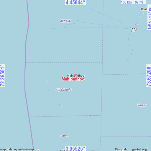
Mahibadhoo GPS coordinates[2]
3° 45' 25.668" North, 72° 58' 8.148" East
| Map corner | latitude | longitude |
|---|---|---|
| Upper-left | 4.45844°, | 72.26581° |
| Center: | 3.75713°, | 72.96893° |
| Lower-right: | 3.05525°, | 73.67206° |
| Map W x H: | 156×156 km | = 96.9×96.9mi |
| max Lat: | 6.88744° ⇑42.9% North |
| Mahibadhoo: | 3.75713° |
| min Lat: | ⇓57.1% South -0.6° |
| min Long | Mahibadhoo | max Long |
| 72.89437° | 72.96893° | 73.56667° |
| W 3.6%⇐ | ⇒96.4% E |
Elevation
Elevation of Mahibadhoo is 9 m = 30 ft, and this is 1.7 m = 6 ft above average elevation for this country.
| Max E: |
12 m = 39 ft | 39.3% |
| Mahibadhoo | 9 m 30 ft | |
| Avg. | 7.3 m = 24 ft | |
Min E: |
-1 m = -3 ft | 60.7% |
See also: Maldives elevation on elevation.city.
Geographical zone
Mahibadhoo is located in North Torrid zone (between Equator and Tropic of Cancer). Distance of Equator is 417.8 km =259.6 mi to South.| Distance of | km | miles | from Mahibadhoo |
|---|---|---|---|
| North Pole | 9589.3 | 5958.5 | to North |
| Arctic Circle | 6983.4 | 4339.3 | to North |
| Tropic Cancer | 2188.2 | 1359.7 | to North |
| Equator | 417.8 | 259.6 | to South |


Nearby cities:
15 places around Mahibadhoo: (largest is in red/bold)
• Buruni
134.1 km =83.3 mi,  173°
173°
• Diyamigili
162.8 km =101.2 mi, 165°
• Eydhafushi
150.1 km =93.3 mi,  4°
4°
• Felidhoo
71.6 km =44.5 mi,  116°
116°
• Guraidhoo
57.4 km =35.7 mi,  73°
73°
• Guraidhoo
163.9 km =101.8 mi, 166°
• Hulhumale
81 km =50.3 mi,  51°
51°
• Kudahuvadhoo
121.1 km =75.2 mi,  183°
183°
• Maafushi
61.4 km =38.2 mi, 70°
• Madifushi
161.6 km =100.4 mi,  164°
164°
• Male
75.8 km =47.1 mi, 52°
• Muli
114.6 km =71.2 mi,  144°
144°
• Open Stage
150.3 km =93.4 mi, 4°
• Veymandoo
175.1 km =108.8 mi, 175°
• Vilufushi
144.4 km =89.7 mi, 164°
Sources, notices
• [Note1] Compared only with cities in Maldives existing in our database
• [Src1] Map data: © OpenStreetMap contributors (CC-BY-SA)
• [Src2] Other city data from geonames.org with taken over terms of usage.
• [Src3] Geographical zone / Annual Mean Temperature by Robert A. Rohde @ Wikipedia
