Veymandoo geodata
Veymandoo (Thaa Atholhu) is a seat of a first-order administrative division; located in Maldives in Indian/Maldives (GMT+5) time zone. With population of 1,100 people, there are 23 cities with bigger population in this country. Compared to other cities in Maldives, 75% of cities are located further ↑North; 71.4% of cities are located further →East and 89.3% of cities have lower elevation than Veymandoo. Note1


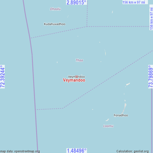
Veymandoo GPS coordinates[2]
2° 11' 15.792" North, 73° 5' 44.016" East
| Map corner | latitude | longitude |
|---|---|---|
| Upper-left | 2.89015°, | 72.39244° |
| Center: | 2.18772°, | 73.09556° |
| Lower-right: | 1.48496°, | 73.79869° |
| Map W x H: | 156.2×156.2 km | = 97.1×97.1mi |
| max Lat: | 6.88744° ⇑75% North |
| Veymandoo: | 2.18772° |
| min Lat: | ⇓25% South -0.6° |
| min Long | Veymandoo | max Long |
| 72.89437° | 73.09556° | 73.56667° |
| W 28.6%⇐ | ⇒71.4% E |
Elevation
Elevation of Veymandoo is 10 m = 33 ft, and this is 2.7 m = 9 ft above average elevation for this country.
| Max E: |
12 m = 39 ft | 10.7% |
| Veymandoo | 10 m 33 ft | |
| Avg. | 7.3 m = 24 ft | |
Min E: |
-1 m = -3 ft | 89.3% |
See also: Maldives elevation on elevation.city.
Geographical zone
Veymandoo is located in North Torrid zone (between Equator and Tropic of Cancer). Distance of Equator is 243.3 km =151.2 mi to South.| Distance of | km | miles | from Veymandoo |
|---|---|---|---|
| North Pole | 9763.8 | 6066.9 | to North |
| Arctic Circle | 7157.9 | 4447.7 | to North |
| Tropic Cancer | 2362.7 | 1468.1 | to North |
| Equator | 243.3 | 151.2 | to South |


Nearby cities:
15 places around Veymandoo: (largest is in red/bold)
• Buruni
41.3 km =25.7 mi,  1°
1°
• Diyamigili
31.9 km =19.8 mi,  57°
57°
• Felidhoo
151.3 km =94 mi,  19°
19°
• Fonadhoo
60.1 km =37.3 mi,  131°
131°
• Guraidhoo
29.1 km =18.1 mi, 58°
• Guraidhoo
194.8 km =121 mi,  12°
12°
• Hithadhoo
54.3 km =33.7 mi,  143°
143°
• Kudahuvadhoo
58.2 km =36.2 mi,  337°
337°
• Maafushi
200 km =124.3 mi, 12°
• Madifushi
34.3 km =21.3 mi, 57°
• Mahibadhoo
175.1 km =108.8 mi,  355°
355°
• Muli
96.5 km =60 mi,  32°
32°
• Thinadhoo
184.6 km =114.7 mi,  183°
183°
• Viligili
163.2 km =101.4 mi,  166°
166°
• Vilufushi
42.3 km =26.3 mi, 34°
Sources, notices
• [Note1] Compared only with cities in Maldives existing in our database
• [Src1] Map data: © OpenStreetMap contributors (CC-BY-SA)
• [Src2] Other city data from geonames.org with taken over terms of usage.
• [Src3] Geographical zone / Annual Mean Temperature by Robert A. Rohde @ Wikipedia
