Cenotillo geodata
Cenotillo (Yucatán) is a seat of a second-order administrative division; located in Mexico in America/Merida (GMT-6) time zone. With population of 3,272 people, there are 2774 cities with bigger population in this country. Compared to other cities in Mexico, 76% of cities are located further ↓South; 99.1% of cities are located further ←West and 90% of cities have higher elevation than Cenotillo. Note1


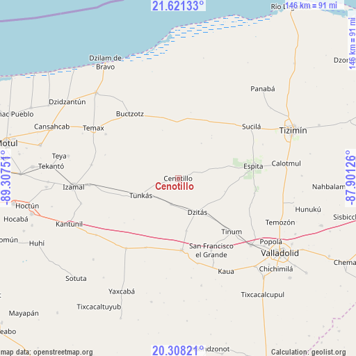
Cenotillo GPS coordinates[2]
20° 57' 58.356" North, 88° 36' 15.768" West
| Map corner | latitude | longitude |
|---|---|---|
| Upper-left | 21.62133°, | -89.30751° |
| Center: | 20.96621°, | -88.60438° |
| Lower-right: | 20.30821°, | -87.90126° |
| Map W x H: | 146×146 km | = 90.7×90.7mi |
| max Lat: | 32.7° ⇑24% North |
| Cenotillo: | 20.96621° |
| min Lat: | ⇓76% South 14.53588° |
| min Long | Cenotillo | max Long |
| -117.105° | -88.60438° | -86.73105° |
| W 99.1%⇐ | ⇒0.90000000000001% E |
Elevation
Elevation of Cenotillo is 24 m = 79 ft, and this is 1229.7 m = 4034 ft below average elevation for this country.
| Max E: |
3497 m = 11473 ft | 90% |
| Avg. | 1253.7 m = 4113 ft | |
| Cenotillo | 24 m = 79 ft | |
Min E: |
-1 m = -3 ft | 10% |
See also: Mexico elevation on elevation.city.
Geographical zone
Cenotillo is located in North Torrid zone (between Equator and Tropic of Cancer). Distance of this Northern Tropic circle is 274.7 km =170.7 mi to North.| Distance of | km | miles | from Cenotillo |
|---|---|---|---|
| North Pole | 7675.8 | 4769.5 | to North |
| Arctic Circle | 5070 | 3150.4 | to North |
| Tropic Cancer | 274.7 | 170.7 | to North |
| Equator | 2331.2 | 1448.5 | to South |


Nearby cities:
15 places around Cenotillo: (largest is in red/bold)
• Buctzotz
32.8 km =20.4 mi,  323°
323°
• Chichén-Itzá
33.5 km =20.8 mi,  173°
173°
• Dzitás
16 km =9.9 mi,  150°
150°
• Dzoncauich
34.7 km =21.6 mi,  301°
301°
• Espita
31.3 km =19.4 mi,  80°
80°
• Kunche
31.9 km =19.8 mi,  101°
101°
• Libre Unión
35.9 km =22.3 mi,  216°
216°
• Nacuche
32.4 km =20.1 mi, 98°
• Piste
29.7 km =18.5 mi,  176°
176°
• Quintana Roo
11.1 km =6.9 mi,  194°
194°
• San Francisco Grande
32.5 km =20.2 mi,  155°
155°
• Tinum
31.2 km =19.4 mi,  134°
134°
• Tunkas
16.8 km =10.4 mi,  245°
245°
• Xocempich
21.9 km =13.6 mi, 171°
• Yokdzonot
31.5 km =19.6 mi,  204°
204°
Sources, notices
• [Note1] Compared only with cities in Mexico existing in our database
• [Src1] Map data: © OpenStreetMap contributors (CC-BY-SA)
• [Src2] Other city data from geonames.org with taken over terms of usage.
• [Src3] Geographical zone / Annual Mean Temperature by Robert A. Rohde @ Wikipedia
