Barceló Maya geodata
Barceló Maya (Quintana Roo) is a populated place; located in Mexico in America/Cancun (GMT-5) time zone. With population of 606 people, there are 14202 cities with bigger population in this country. Compared to other cities in Mexico, 67.5% of cities are located further ↓South; 99.9% of cities are located further ←West and 98.7% of cities have higher elevation than Barceló Maya. Note1


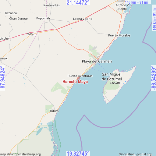
Barceló Maya GPS coordinates[2]
20° 29' 15" North, 87° 14' 45.996" West
| Map corner | latitude | longitude |
|---|---|---|
| Upper-left | 21.14472°, | -87.94924° |
| Center: | 20.4875°, | -87.24611° |
| Lower-right: | 19.82745°, | -86.54299° |
| Map W x H: | 146.5×146.5 km | = 91×91mi |
| max Lat: | 32.7° ⇑32.5% North |
| Barceló Maya: | 20.4875° |
| min Lat: | ⇓67.5% South 14.53588° |
| min Long | Barceló Maya | max Long |
| -117.105° | -87.24611° | -86.73105° |
| W 99.9%⇐ | ⇒0.099999999999994% E |
Elevation
Elevation of Barceló Maya is 7 m = 23 ft, and this is 1246.7 m = 4090 ft below average elevation for this country.
| Max E: |
3497 m = 11473 ft | 98.7% |
| Avg. | 1253.7 m = 4113 ft | |
| Barceló Maya | 7 m = 23 ft | |
Min E: |
-1 m = -3 ft | 1.3% |
See also: Mexico elevation on elevation.city.
Geographical zone
Barceló Maya is located in North Torrid zone (between Equator and Tropic of Cancer). Distance of this Northern Tropic circle is 327.9 km =203.7 mi to North.| Distance of | km | miles | from Barceló Maya |
|---|---|---|---|
| North Pole | 7729.1 | 4802.6 | to North |
| Arctic Circle | 5123.2 | 3183.4 | to North |
| Tropic Cancer | 327.9 | 203.7 | to North |
| Equator | 2278 | 1415.5 | to South |


Nearby cities:
15 places around Barceló Maya: (largest is in red/bold)
• Akumal
12.3 km =7.6 mi,  215°
215°
• Ciudad Chemuyil
19 km =11.8 mi, 215°
• Coba
51.3 km =31.9 mi,  269°
269°
• Cozumel
31.6 km =19.6 mi,  87°
87°
• El Ideal
53.7 km =33.4 mi,  324°
324°
• El Tintal
50.5 km =31.4 mi,  333°
333°
• Francisco Uh May
38.4 km =23.9 mi,  249°
249°
• Ignacio Zaragoza
52.6 km =32.7 mi, 326°
• Las Fincas
34.4 km =21.4 mi, 88°
• Leona Vicario
56 km =34.8 mi,  4°
4°
• Macario Gómez
37.5 km =23.3 mi, 246°
• Playa del Carmen
23.3 km =14.5 mi,  48°
48°
• Puerto Aventuras
2.5 km =1.6 mi, 54°
• San Francisco
45.7 km =28.4 mi, 324°
• Tulum
38.1 km =23.7 mi, 216°
Sources, notices
• [Note1] Compared only with cities in Mexico existing in our database
• [Src1] Map data: © OpenStreetMap contributors (CC-BY-SA)
• [Src2] Other city data from geonames.org with taken over terms of usage.
• [Src3] Geographical zone / Annual Mean Temperature by Robert A. Rohde @ Wikipedia
