Cozumel geodata
Cozumel (Quintana Roo) is a seat of a second-order administrative division; located in Mexico in America/Cancun (GMT-5) time zone. With population of 77,236 people, there are 160 cities with bigger population in this country. Compared to other cities in Mexico, 67.8% of cities are located further ↓South; 100% of cities are located further ←West and 98.7% of cities have higher elevation than Cozumel. Note1


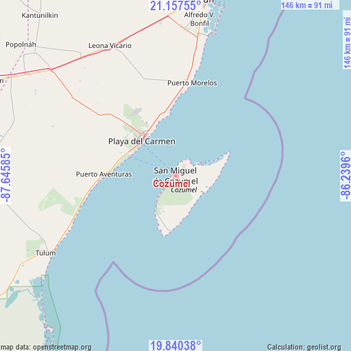
Cozumel GPS coordinates[2]
20° 30' 1.368" North, 86° 56' 33.792" West
| Map corner | latitude | longitude |
|---|---|---|
| Upper-left | 21.15755°, | -87.64585° |
| Center: | 20.50038°, | -86.94272° |
| Lower-right: | 19.84038°, | -86.2396° |
| Map W x H: | 146.5×146.5 km | = 91×91mi |
| max Lat: | 32.7° ⇑32.2% North |
| Cozumel: | 20.50038° |
| min Lat: | ⇓67.8% South 14.53588° |
| min Long | Cozumel | max Long |
| -117.105° | -86.94272° | -86.73105° |
| W 100%⇐ | ⇒0% E |
Elevation
Elevation of Cozumel is 7 m = 23 ft, and this is 1246.7 m = 4090 ft below average elevation for this country.
| Max E: |
3497 m = 11473 ft | 98.7% |
| Avg. | 1253.7 m = 4113 ft | |
| Cozumel | 7 m = 23 ft | |
Min E: |
-1 m = -3 ft | 1.3% |
See also: Cozumel elevation on elevation.city.
Geographical zone
Cozumel is located in North Torrid zone (between Equator and Tropic of Cancer). Distance of this Northern Tropic circle is 326.5 km =202.9 mi to North.| Distance of | km | miles | from Cozumel |
|---|---|---|---|
| North Pole | 7727.6 | 4801.7 | to North |
| Arctic Circle | 5121.7 | 3182.5 | to North |
| Tropic Cancer | 326.5 | 202.9 | to North |
| Equator | 2279.4 | 1416.4 | to South |


Nearby cities:
15 places around Cozumel: (largest is in red/bold)
• Akumal
40.4 km =25.1 mi,  253°
253°
• Alfredo V. Bonfil
66.1 km =41.1 mi,  8°
8°
• Barceló Maya
31.6 km =19.6 mi,  267°
267°
• Ciudad Chemuyil
46 km =28.6 mi, 248°
• El Porvenir
64.5 km =40.1 mi,  354°
354°
• El Tintal
69.7 km =43.3 mi,  308°
308°
• Francisco Uh May
69.1 km =42.9 mi,  257°
257°
• Ignacio Zaragoza
73.9 km =45.9 mi,  304°
304°
• Las Fincas
2.8 km =1.7 mi,  95°
95°
• Leona Vicario
60.7 km =37.7 mi,  333°
333°
• Macario Gómez
68 km =42.3 mi, 255°
• Playa del Carmen
20.1 km =12.5 mi, 314°
• Puerto Aventuras
29.6 km =18.4 mi, 270°
• San Francisco
68.4 km =42.5 mi, 301°
• Tulum
63 km =39.1 mi,  239°
239°
Sources, notices
• [Note1] Compared only with cities in Mexico existing in our database
• [Src1] Map data: © OpenStreetMap contributors (CC-BY-SA)
• [Src2] Other city data from geonames.org with taken over terms of usage.
• [Src3] Geographical zone / Annual Mean Temperature by Robert A. Rohde @ Wikipedia
