Akumal geodata
Akumal (Quintana Roo) is a populated place; located in Mexico in America/Cancun (GMT-5) time zone. With population of 1,310 people, there are 6625 cities with bigger population in this country. Compared to other cities in Mexico, 65.6% of cities are located further ↓South; 99.9% of cities are located further ←West and 99.1% of cities have higher elevation than Akumal. Note1


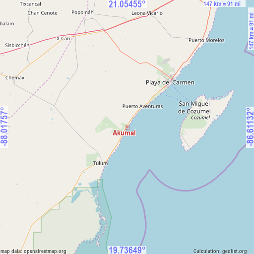
Akumal GPS coordinates[2]
20° 23' 48.948" North, 87° 18' 51.984" West
| Map corner | latitude | longitude |
|---|---|---|
| Upper-left | 21.05455°, | -88.01757° |
| Center: | 20.39693°, | -87.31444° |
| Lower-right: | 19.73649°, | -86.61132° |
| Map W x H: | 146.6×146.6 km | = 91.1×91.1mi |
| max Lat: | 32.7° ⇑34.4% North |
| Akumal: | 20.39693° |
| min Lat: | ⇓65.6% South 14.53588° |
| min Long | Akumal | max Long |
| -117.105° | -87.31444° | -86.73105° |
| W 99.9%⇐ | ⇒0.099999999999994% E |
Elevation
Elevation of Akumal is 6 m = 20 ft, and this is 1247.7 m = 4094 ft below average elevation for this country.
| Max E: |
3497 m = 11473 ft | 99.1% |
| Avg. | 1253.7 m = 4113 ft | |
| Akumal | 6 m = 20 ft | |
Min E: |
-1 m = -3 ft | 0.9% |
See also: Mexico elevation on elevation.city.
Geographical zone
Akumal is located in North Torrid zone (between Equator and Tropic of Cancer). Distance of this Northern Tropic circle is 338 km =210 mi to North.| Distance of | km | miles | from Akumal |
|---|---|---|---|
| North Pole | 7739.1 | 4808.9 | to North |
| Arctic Circle | 5133.2 | 3189.6 | to North |
| Tropic Cancer | 338 | 210 | to North |
| Equator | 2267.9 | 1409.2 | to South |


Nearby cities:
15 places around Akumal: (largest is in red/bold)
• Barceló Maya
12.3 km =7.6 mi,  35°
35°
• Ciudad Chemuyil
6.7 km =4.2 mi,  216°
216°
• Coba
45.2 km =28.1 mi,  282°
282°
• Cozumel
40.4 km =25.1 mi,  73°
73°
• El Ideal
58.9 km =36.6 mi,  336°
336°
• El Tintal
57.3 km =35.6 mi, 344°
• Francisco Uh May
29 km =18 mi,  262°
262°
• Ignacio Zaragoza
58.2 km =36.2 mi, 337°
• Las Fincas
43 km =26.7 mi, 74°
• Macario Gómez
27.7 km =17.2 mi, 259°
• Nuevo Xcán
60.5 km =37.6 mi,  330°
330°
• Playa del Carmen
35.4 km =22 mi, 43°
• Puerto Aventuras
14.7 km =9.1 mi, 38°
• San Francisco
51.1 km =31.8 mi, 337°
• Tulum
25.8 km =16 mi, 217°
Sources, notices
• [Note1] Compared only with cities in Mexico existing in our database
• [Src1] Map data: © OpenStreetMap contributors (CC-BY-SA)
• [Src2] Other city data from geonames.org with taken over terms of usage.
• [Src3] Geographical zone / Annual Mean Temperature by Robert A. Rohde @ Wikipedia
