Chilpancingo geodata
Chilpancingo (Guerrero) is a seat of a first-order administrative division; located in Mexico in America/Mexico_City (GMT-6) time zone. With population of 187,251 people, there are 90 cities with bigger population in this country. Compared to other cities in Mexico, 82.6% of cities are located further ↑North; 57% of cities are located further →East and 54% of cities have higher elevation than Chilpancingo. Note1


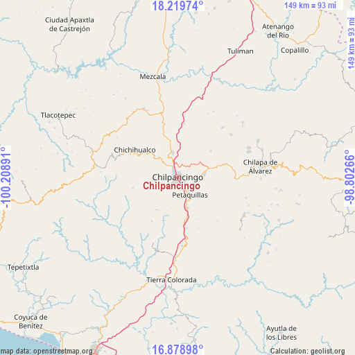
Chilpancingo GPS coordinates[2]
17° 33' 2.16" North, 99° 30' 20.808" West
| Map corner | latitude | longitude |
|---|---|---|
| Upper-left | 18.21974°, | -100.20891° |
| Center: | 17.5506°, | -99.50578° |
| Lower-right: | 16.87898°, | -98.80266° |
| Map W x H: | 149.1×149.1 km | = 92.6×92.6mi |
| max Lat: | 32.7° ⇑82.6% North |
| Chilpancingo: | 17.5506° |
| min Lat: | ⇓17.4% South 14.53588° |
| min Long | Chilpancingo | max Long |
| -117.105° | -99.50578° | -86.73105° |
| W 43%⇐ | ⇒57% E |
Elevation
Elevation of Chilpancingo is 1242 m = 4075 ft, and this is 11.7 m = 38 ft below average elevation for this country.
| Max E: |
3497 m = 11473 ft | 54% |
| Avg. | 1253.7 m = 4113 ft | |
| Chilpancingo | 1242 m = 4075 ft | |
Min E: |
-1 m = -3 ft | 46% |
See also: Chilpancingo elevation on elevation.city.
Geographical zone
Chilpancingo is located in North Torrid zone (between Equator and Tropic of Cancer). Distance of this Northern Tropic circle is 654.5 km =406.7 mi to North.| Distance of | km | miles | from Chilpancingo |
|---|---|---|---|
| North Pole | 8055.6 | 5005.5 | to North |
| Arctic Circle | 5449.7 | 3386.3 | to North |
| Tropic Cancer | 654.5 | 406.7 | to North |
| Equator | 1951.4 | 1212.5 | to South |


Nearby cities:
15 places around Chilpancingo: (largest is in red/bold)
• Acatempa
18 km =11.2 mi,  55°
55°
• Amojileca
7 km =4.3 mi,  287°
287°
• Atliaca
17.9 km =11.1 mi,  51°
51°
• Atlixtac
16.9 km =10.5 mi,  308°
308°
• El Fresno
15.7 km =9.8 mi,  212°
212°
• El Palmar
15.1 km =9.4 mi,  317°
317°
• Mazatlán
13.4 km =8.3 mi,  161°
161°
• Mochitlán
16.8 km =10.4 mi,  121°
121°
• Palo Blanco
16.9 km =10.5 mi,  165°
165°
• Petaquillas
8.9 km =5.5 mi,  143°
143°
• San Vicente
19.3 km =12 mi,  257°
257°
• Tepechicotlán
12.2 km =7.6 mi,  128°
128°
• Tixtla de Guerrero
11.6 km =7.2 mi,  80°
80°
• Zacatzonapa
18.1 km =11.2 mi,  107°
107°
• Zumpango del Río
11.8 km =7.3 mi,  348°
348°
Sources, notices
• [Note1] Compared only with cities in Mexico existing in our database
• [Src1] Map data: © OpenStreetMap contributors (CC-BY-SA)
• [Src2] Other city data from geonames.org with taken over terms of usage.
• [Src3] Geographical zone / Annual Mean Temperature by Robert A. Rohde @ Wikipedia
