Atliaca geodata
Atliaca (Guerrero) is a populated place; located in Mexico in America/Mexico_City (GMT-6) time zone. With population of 5,997 people, there are 1557 cities with bigger population in this country. Compared to other cities in Mexico, 81.8% of cities are located further ↑North; 55.3% of cities are located further →East and 53% of cities have higher elevation than Atliaca. Note1


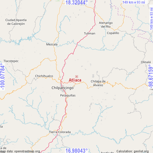
Atliaca GPS coordinates[2]
17° 39' 6.048" North, 99° 22' 28.956" West
| Map corner | latitude | longitude |
|---|---|---|
| Upper-left | 18.32044°, | -100.07784° |
| Center: | 17.65168°, | -99.37471° |
| Lower-right: | 16.98043°, | -98.67159° |
| Map W x H: | 149×149 km | = 92.6×92.6mi |
| max Lat: | 32.7° ⇑81.8% North |
| Atliaca: | 17.65168° |
| min Lat: | ⇓18.2% South 14.53588° |
| min Long | Atliaca | max Long |
| -117.105° | -99.37471° | -86.73105° |
| W 44.7%⇐ | ⇒55.3% E |
Elevation
Elevation of Atliaca is 1291 m = 4236 ft, and this is 37.3 m = 122 ft above average elevation for this country.
| Max E: |
3497 m = 11473 ft | 53% |
| Atliaca | 1291 m 4236 ft | |
| Avg. | 1253.7 m = 4113 ft | |
Min E: |
-1 m = -3 ft | 47% |
See also: Mexico elevation on elevation.city.
Geographical zone
Atliaca is located in North Torrid zone (between Equator and Tropic of Cancer). Distance of this Northern Tropic circle is 643.2 km =399.7 mi to North.| Distance of | km | miles | from Atliaca |
|---|---|---|---|
| North Pole | 8044.4 | 4998.6 | to North |
| Arctic Circle | 5438.5 | 3379.3 | to North |
| Tropic Cancer | 643.2 | 399.7 | to North |
| Equator | 1962.7 | 1219.6 | to South |


Nearby cities:
15 places around Atliaca: (largest is in red/bold)
• Acatempa
1.3 km =0.8 mi,  136°
136°
• Ahuihuiyuco
15.8 km =9.8 mi,  98°
98°
• Almolonga
8.6 km =5.3 mi, 100°
• Apango
11.1 km =6.9 mi,  25°
25°
• Ayotzinapa
16.1 km =10 mi,  63°
63°
• Chilacachapa
14.7 km =9.1 mi, 136°
• Hueyitlalpan
8.8 km =5.5 mi,  72°
72°
• Huitziltepec
16.1 km =10 mi,  316°
316°
• Pochahuizco
16.2 km =10.1 mi,  84°
84°
• Tepehuisco
14 km =8.7 mi,  111°
111°
• Tepozcuautla
15.9 km =9.9 mi, 101°
• Tixtla de Guerrero
9.7 km =6 mi,  194°
194°
• Topiltepec
16.1 km =10 mi,  90°
90°
• Zoquiapa
15.8 km =9.8 mi, 138°
• Zotoltitlán
11.2 km =7 mi,  51°
51°
Sources, notices
• [Note1] Compared only with cities in Mexico existing in our database
• [Src1] Map data: © OpenStreetMap contributors (CC-BY-SA)
• [Src2] Other city data from geonames.org with taken over terms of usage.
• [Src3] Geographical zone / Annual Mean Temperature by Robert A. Rohde @ Wikipedia
