Texcatepec geodata
Texcatepec (Veracruz) is a seat of a second-order administrative division; located in Mexico in America/Mexico_City (GMT-6) time zone. With population of 1,114 people, there are 7797 cities with bigger population in this country. Compared to other cities in Mexico, 69.7% of cities are located further ↓South; 59.1% of cities are located further ←West and 66.4% of cities have lower elevation than Texcatepec. Note1


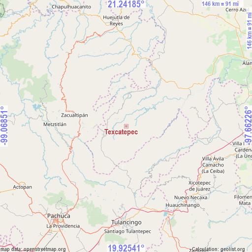
Texcatepec GPS coordinates[2]
20° 35' 6.18" North, 98° 21' 55.368" West
| Map corner | latitude | longitude |
|---|---|---|
| Upper-left | 21.24185°, | -99.06851° |
| Center: | 20.58505°, | -98.36538° |
| Lower-right: | 19.92541°, | -97.66226° |
| Map W x H: | 146.4×146.4 km | = 91×91mi |
| max Lat: | 32.7° ⇑30.3% North |
| Texcatepec: | 20.58505° |
| min Lat: | ⇓69.7% South 14.53588° |
| min Long | Texcatepec | max Long |
| -117.105° | -98.36538° | -86.73105° |
| W 59.1%⇐ | ⇒40.9% E |
Elevation
Elevation of Texcatepec is 1859 m = 6099 ft, and this is 605.3 m = 1986 ft above average elevation for this country.
| Max E: |
3497 m = 11473 ft | 33.6% |
| Texcatepec | 1859 m 6099 ft | |
| Avg. | 1253.7 m = 4113 ft | |
Min E: |
-1 m = -3 ft | 66.4% |
See also: Mexico elevation on elevation.city.
Geographical zone
Texcatepec is located in North Torrid zone (between Equator and Tropic of Cancer). Distance of this Northern Tropic circle is 317.1 km =197 mi to North.| Distance of | km | miles | from Texcatepec |
|---|---|---|---|
| North Pole | 7718.2 | 4795.9 | to North |
| Arctic Circle | 5112.3 | 3176.6 | to North |
| Tropic Cancer | 317.1 | 197 | to North |
| Equator | 2288.8 | 1422.2 | to South |


Nearby cities:
15 places around Texcatepec: (largest is in red/bold)
• Ayotuxtla
9.6 km =6 mi,  42°
42°
• Carpinteros
18.1 km =11.2 mi,  270°
270°
• El Pericón
13.2 km =8.2 mi,  61°
61°
• Huayacocotla
13.2 km =8.2 mi,  245°
245°
• José María Pino Suárez
17.5 km =10.9 mi,  350°
350°
• La Florida
3 km =1.9 mi,  69°
69°
• La Mirra
4.9 km =3 mi,  18°
18°
• La Selva
14.7 km =9.1 mi,  262°
262°
• Las Canoas
2 km =1.2 mi, 55°
• Pie de la Cuesta
2.7 km =1.7 mi,  6°
6°
• Tlachichilco
17.8 km =11.1 mi,  76°
76°
• Tzicatlán
16.7 km =10.4 mi,  53°
53°
• Zacualpan
17 km =10.6 mi,  173°
173°
• Zilacatipan
10.4 km =6.5 mi,  319°
319°
• Zonzonapa
13.9 km =8.6 mi,  326°
326°
Sources, notices
• [Note1] Compared only with cities in Mexico existing in our database
• [Src1] Map data: © OpenStreetMap contributors (CC-BY-SA)
• [Src2] Other city data from geonames.org with taken over terms of usage.
• [Src3] Geographical zone / Annual Mean Temperature by Robert A. Rohde @ Wikipedia
